This is a reprint of a news release posted by National Snow and Ice Data Center (NSIDC) on Sep 19, 2012.
![]()

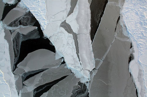
Sea ice can take many forms, as seen in this image of Arctic sea ice from a recent Operation IceBridge aerial survey. Varying thicknesses of sea ice are shown here, from thin, nearly transparent layers to thicker, older sea ice covered with snow. —Credit: NASA
Arctic sea ice cover likely melted to its minimum extent for the year on September 16, according to scientists at the National Snow and Ice Data Center (NSIDC). Sea ice extent fell to 3.41 million square kilometers (1.32 million square miles), now the lowest summer minimum extent in the satellite record.
“We are now in uncharted territory,” said NSIDC Director Mark Serreze. “While we’ve long known that as the planet warms up, changes would be seen first and be most pronounced in the Arctic, few of us were prepared for how rapidly the changes would actually occur.”
Arctic sea ice cover grows each winter as the sun sets for several months, and shrinks each summer as the sun rises higher in the northern sky. Each year, the Arctic sea ice reaches its minimum extent in September. This year’s minimum follows a record-breaking summer of low sea ice extents in the Arctic. Sea ice extent fell to 4.10 million square kilometers (1.58 million square miles) on August 26, breaking the lowest extent on record set on September 18, 2007 of 4.17 million square kilometers (1.61 million square miles). On September 4, it fell below 4.00 million square kilometers (1.54 million square miles), another first in the 33-year satellite record.
“The strong late season decline is indicative of how thin the ice cover is,” said NSIDC scientist Walt Meier. “Ice has to be quite thin to continue melting away as the sun goes down and fall approaches.”
NSIDC scientists have observed fundamental changes in the Arctic’s sea ice cover. The Arctic used to be dominated by multiyear ice, or ice that survived through several years. Lately, the Arctic is increasingly characterized by seasonal ice cover and large areas are now prone to completely melt away in summer.
“The later minimum date is somewhat surprising because we expected that the late melt in the Chukchi and East Siberian seas would result in cool surface waters that would quickly refreeze once the atmosphere cooled,” Meier said. “However, ice loss continued north of the Laptev Sea, opening up a gap in the ice cover that reduced extent.”
Arctic sea ice has long been recognized as a sensitive climate indicator. The region’s sea ice extent--defined by NSIDC as the total area covered by at least 15 percent of ice—varies from year to year because of changeable weather conditions. However, ice extent has shown a dramatic overall decline over the past thirty years. This year’s minimum will be nearly 50 percent lower than the 1979 to 2000 average.
NSIDC lead scientist Ted Scambos said that thinning ice, along with early loss of snow, are rapidly warming the Arctic. “But a wider impact may come from the increased heat and moisture the warmer Arctic is adding to the climate system,” he said. “This will gradually affect climate in the areas where we live,” he added. “We have a less polar pole—and so there will be more variations and extremes.”
NSIDC scientist Julienne Stroeve said, “Recent climate models suggest that ice-free conditions may happen before 2050, though the observed rate of decline remains faster than many of the models are able to capture.”
Serreze said, “While lots of people talk about opening of the Northwest Passage through the Canadian Arctic islands and the Northern Sea Route along the Russian coast, twenty years from now from now in August you might be able to take a ship right across the Arctic Ocean.”
For more details on the minimum ice extent, see the Arctic Sea Ice News and Analysis website. The site provides regular updates by NSIDC scientists on the condition of the Arctic sea ice.
Please note that this number is preliminary--changing weather conditions could still push the ice extent lower. During the first week of October, NSIDC will issue a full analysis of the possible causes behind this year's ice conditions, including a discussion of how the summer's low ice extent may affect the winter ice growth season ahead, and graphics comparing this year to the long-term record.
For the scientific report and data images, please see NSIDC's Arctic Sea Ice News and Analysis.
A news release by NASA is available at http://www.nasa.gov/topics/earth/features/2012-seaicemin.html
NASA's image of the September 16 minimum may be downloaded here: http://svs.gsfc.nasa.gov/vis/a000000/a003900/a003998/Minimum_SeaIce_Area_2012_09_16.1080.tif
Posted by John Hartz on Saturday, 22 September, 2012
 |
The Skeptical Science website by Skeptical Science is licensed under a Creative Commons Attribution 3.0 Unported License. |