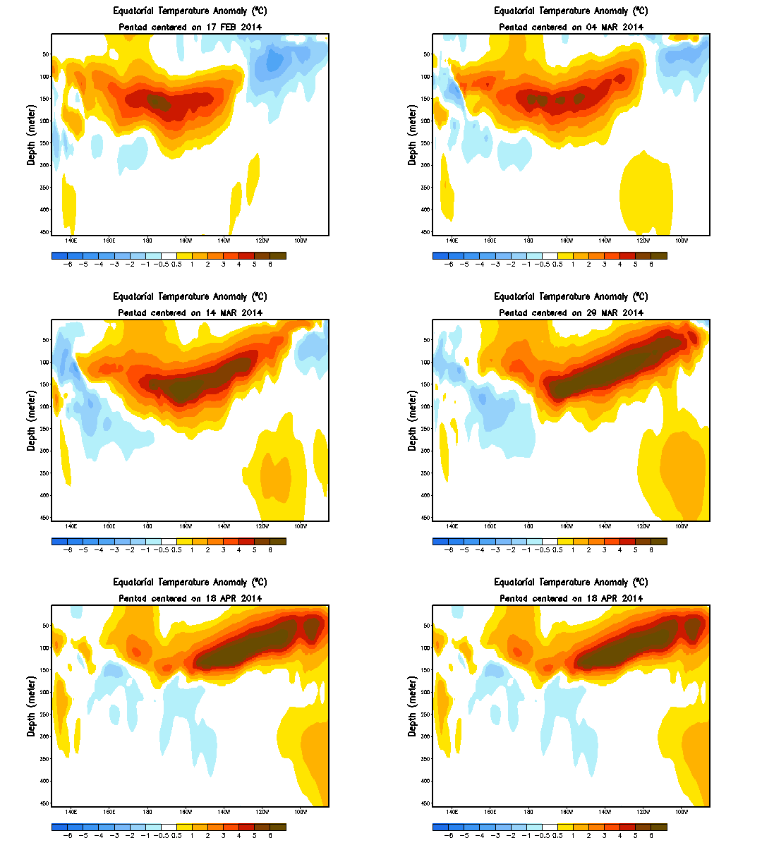

Figure 1 - Ocean temperature vs depth anomalies for the equatorial Pacific in 2014. Image from NOAA CPC.
The prevailing (dominant) winds in the tropical Pacific Ocean are the easterly trade winds which blow toward the west off the equator. These winds exist, in part, because the strong solar heating of the ocean there drives strong evaporation and the uplift of warm air from the sea surface. Air flows in above the sea surface to take the place of the warm air that has been vertically displaced, but this low-level air curves toward the west due to Earth's eastward rotation - a phenomenon known as the Coriolis Effect.
An index known as the Southern Oscillation Index (SOI) describes the state of the trade winds, and measures the air pressure difference at sea level between Tahiti in the central Pacific and Darwin at the edge of the western Pacific. Under normal conditions the ocean near Tahiti sits in an area of high pressure, and Darwin in an area of low pressure. As the ocean surface is warmer in the western Pacific there is stronger upward movement of warm moist air (convection) and this lowers atmospheric pressure there relative to the ocean around Tahiti. As a result air at sea level moves 'downhill' from high to low pressure and the trade winds are reinforced.
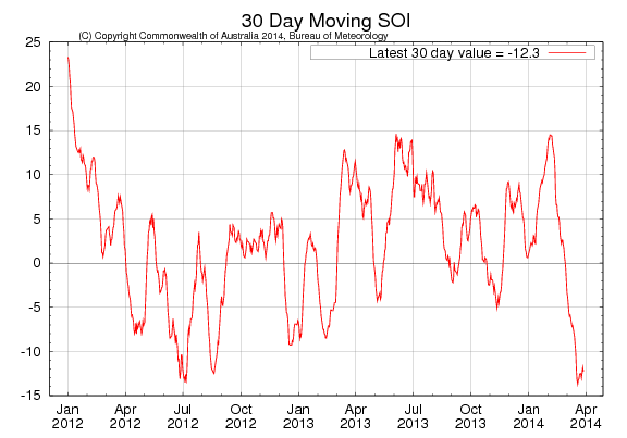
Figure 2 - recent SOI observations showing present negative conditions - an indication that the pressure at Tahiti is currently lower than that at Darwin. Sustained negative values below -8 generally indicate El Niño conditions. Image from the Australian Bureau of Meteorology (BOM).
Persistent trade winds have a curious effect on the motion of the water beneath them. Rather than travelling in the same direction as the wind, as one might intuitively expect, the westerly-moving trade winds induce a net current below the surface (Ekman transport) that travels at right angles (90°) to the wind. This near-surface current moves to the right of the wind direction in the Northern Hemisphere, and to the left in the Southern Hemisphere, and what we end up with is a large-scale movement of water away from the equator near the surface. This surface displacement pulls cold water up from the deep at the equator and creates the 'cold tongue' in the eastern and central Pacific.
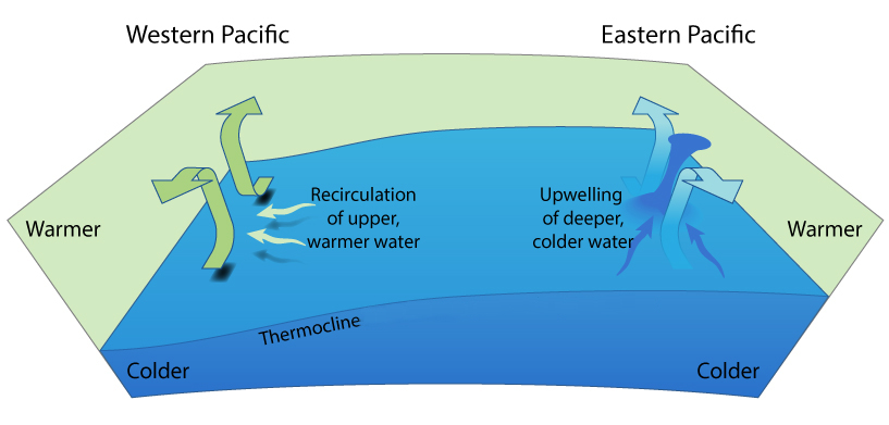
Figure 3 - Upwelling at the equator. The trade winds result in a net flow of water away from the equator due to the Coriolis Force. At the equator subsurface water is drawn up to the surface to replace it. The shallow thermocline (a result of water displacement to the west in the thin equatorial strip where the Coriolis Force drops to zero) in the east enables nutrient rich cold water from the deep to be drawn up to the surface, whereas in the west the deep thermocline results in recirculation within the layer above the thermocline. Image by jg.
Because there is no Coriolis Force in a thin band along the equator, rather than being directed at right angles to the wind (as elsewhere), water is dragged along in the direction of the wind, and piles up in the west and deepens the thermocline - so long as the wind is maintained. This piling up of water mass in the western Pacific also results in the flow of tropical water through the Indonesian archipelago into the Indian Ocean.
Every 2-7 years or thereabouts El Niño signals an abrupt turnaround in this familiar pattern. Unlike La Niña, which is a strengthening of the normal circulation, El Niño comes about when the trade winds weaken. Although the details are vague and the precise triggers for El Niño development are still unknown, the normally intense trade winds weaken and the water piled up in the west begins to move back toward the eastern tropical Pacific in waves known as Kelvin waves. With this relaxation of the trade winds, the flow of warm water through the Indonesian Archipelago begins to wind down too.
Kelvin waves are 'helped' eastward by westerly wind bursts often associated with the formation of tropical lows and cyclones. As these spin clockwise in the Southern Hemisphere and counter- clockwise in the Northern Hemisphere, the equatorward edge results in intense westerly winds. Very close to equator, where the Coriolis force is zero, water is dragged in the same direction as the wind, but outside this thin strip the Coriolis force makes its presence felt. As mentioned earlier, the Coriolis force results in a net movement of water below the surface that is at right angles (90°) to the wind - to the right of motion in the Northern Hemisphere and to the left in the Southern hemisphere. So the flow of water beneath the surface in response to westerly wind bursts moves toward the equator, and any poleward deviations are likewise generally directed back toward the equator. The Coriolis Effect therefore results in the Kelvin wave being confined to the equator, with the equator itself acting as a boundary between the wave travelling west in the two hemispheres.
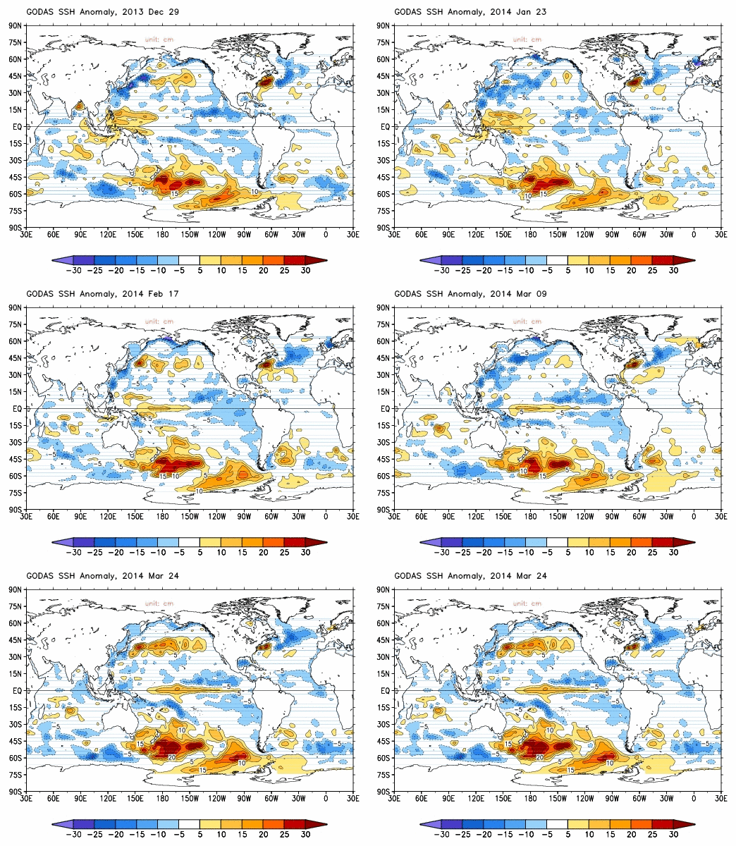
Figure 4 - The transit of the equatorial Kelvin wave across the Pacific basin is revealed by the sea surface height anomalies in 2014. As the warm water moves across the basin the greater thermal expansion of the warmer-than-normal water elevates the sea surface above it. Image from NOAA GODAS.
When the Kelvin waves reach the eastern Pacific they ride up the thermocline slope (the sharp temperature transition between less dense warm surface water and dense cool deep water) toward the surface, depressing the thermocline in the process, and are deflected north and south along the coast of North and South America. This gives the characteristic warm tongue-like feature in sea surface temperatures in the eastern Pacific during the peak phase of El Niño, and also shuts off the upwelling of cold water there. Not only is heat at the surface given up to the cooler atmosphere above, but heat is discharged poleward out of the equatorial zone via the ocean itself in a series of processes that are too long-winded to go into here. Suffice to say that the discharge of heat from the equatorial ocean eventually moves it back to a recharge mode - accumulating warm water for the next El Niño discharge.
The large blob of warm water moving westward in the animation in Figure 1 above may look impressive, but how does it stack up against previous El Niño? The image below (Figure 5) illustrates the size (magnitude) of the equatorial warm water volume anomaly (the warm blob) relative to previous years. This shows that the current blob of warm water is comparable in magnitude, at this stage, to the El Niño event of 1997-1998.
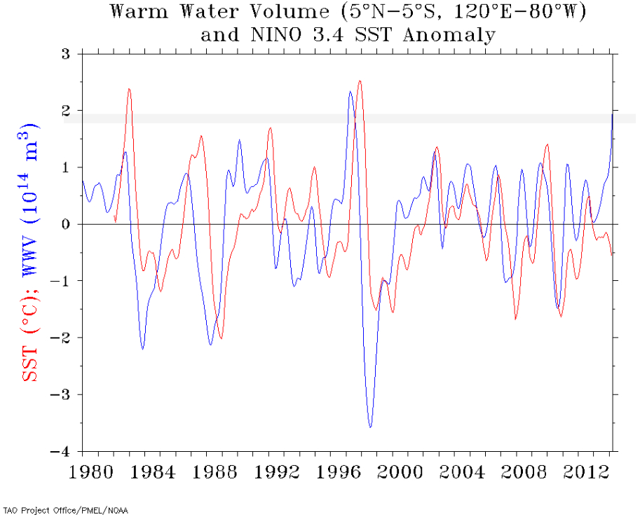
Figure 5 - Equatorial warm water volume anomaly (temperatures above 20°C) over the last few decades and up to early 2014. Warm volume anomaly in blue and sea surface temperatures (SST) for the NINO 3.4 region in red. As the grey band indicates, the 2014 volume anomaly is second only to the event of 1997-1998 in magnitude. Image from the TAO Project at NOAA.
Do larger equatorial warm water volume (WWV) anomalies necessarily translate into larger El Niño events? Although we have only a few decades worth of reliable observations, it does seem that the magnitude of the warm water anomaly typically leads to larger events. The relationship between WWV and eventual sea surface temperatures are apparent in Figure 5, but this was also a key finding of Meinen & McPhadden (2000) - see Figure 6.
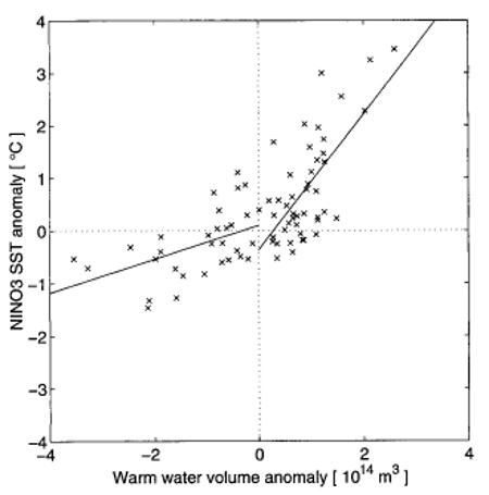
Figure 6 - Comparison of Nino3 SST and WWV anomalies. SST time series has been shifted backward by 7 months to maximize the cross correlation between WWV and SST. Lines represent least square fits to the values, separated into seasons with a negative WWV anomaly and those with a positive WWV anomaly. Image from Meinen & McPhadden (2000).
As stated earlier, we only have just over two decades worth of reasonably detailed observations, so it is by no means guaranteed that a powerful El Niño will develop. But, based on what we have observed and our current physical understanding of the phenomenon, the evolution of an intense El Niño event is possible. It's true the models are not yet predicting a large event, but they did fail to predict the magnitude of the 1997-1998 event, so are not necessarily a reliable indicator of scale this far in advance.
The arrival of a powerful El Niño would cause an abrupt rise in global surface temperatures as heat is discharged from the tropical ocean, and would entail widespread weather-related disruption and suffering around the world - so is not something to be welcomed. We (SkS) will take a look at the likely consequences if such an event unfolds, but for now we'll keep a watchful eye on the Pacific...
Posted by Rob Painting on Wednesday, 23 April, 2014
 |
The Skeptical Science website by Skeptical Science is licensed under a Creative Commons Attribution 3.0 Unported License. |