The information in this post has been incorporated into the new rebuttal to the myth 'satellite [temperature] data are the best data that we have,' available at sks.to/satellite
Satellites don’t measure the Earth’s temperature. Senator Ted Cruz (R-TX) and his fellow climate contrarians love the satellite data, but as Carl Mears of the Remote Sensing Systems (RSS) satellite dataset and Ben Santer recently wrote,
they are not thermometers in space. The satellite [temperature] data ... were obtained from so-called Microwave Sounding Units (MSUs), which measure the microwave emissions of oxygen molecules from broad atmospheric layers. Converting this information to estimates of temperature trends has substantial uncertainties.
Scientists process the raw microwave data, applying a model to make numerous adjustments in order to come up with a synthetic estimate of the atmospheric temperature. Climate scientists have identified many errors in the model, and so it’s undergone several major revisions. It’s a complicated process for many reasons discussed in greater detail in this new Skeptical Science myth rebuttal, and by Mears and Santer.
For example, satellites have a limited lifetime and are replaced (so far there have been 10 different satellites with MSUs); the MSU instruments change - they now use advanced MSUs (AMSUs); their orbits drift and decay due to friction; clouds get in the way; they have to isolate the data from the different layers of the atmosphere, etc.
In a recent Senate hearing, Ted Cruz and one of his witnesses, Judith Curry, claimed “the satellite data are the best data we have.” Most experts disagree.
Video by Peter Sinclair for Yale Climate Connections.
At first blush the claim sounds plausible. After all, satellites are high tech! But how do we decide which data are “the best”? That’s a subjective question, but we can apply some objective criteria to answer it.
For example, as humans, we might consider the temperature where we live (at the Earth’s surface) the most important. Satellites estimate the temperature of the atmosphere, most of which is above us. In fact, as John Christy, who runs the University of Alabama at Huntsville (UAH) satellite dataset recently said,
the main product we use now for greenhouse model validation is the temperature of the Mid-Troposphere
The mid-troposphere is the atmospheric layer from about 25,000–50,000 feet, or about 8–15km in altitude. For perspective, the highest point on the Earth’s surface is on Mount Everest at 29,000 feet (8.8km), and the highest elevation cityin the world is La Rinconada, Peru at 16,700 feet (5.1km). So, by this criterion, surface temperature data would be “the best;” better than satellite data because they’re more relevant to people.
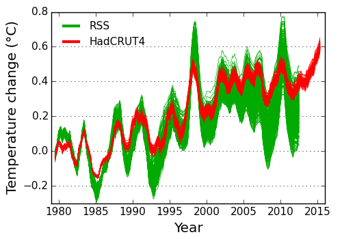
Maybe we value the data with the least uncertainty. Because of all the processing, adjustments, and modeling involved in creating the synthetic temperature data,satellite trends have far greater uncertainty than the surface temperature datasets. By this criterion, surface temperature data would again be “the best;” about five times better than satellite data.

RSS satellite temperature data and HadCRUT4 surface temperature data with uncertainties. Illustration: Kevin Cowtan
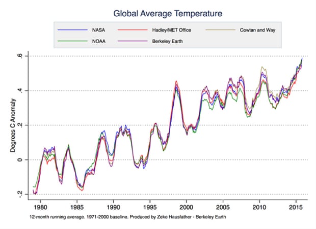
Or perhaps we think it’s important that different groups processing the same raw data in different ways arrive at consistent final temperature estimates. This is true for surface temperature data, which are analyzed by NASA, NOAA, the Met Office,Berkeley Earth, Cowtan & Way, the Japan Meteorological Agency, and others. These groups all arrive at consistent end results.

Various global surface temperature datasets. Illustration: Zeke Hausfather
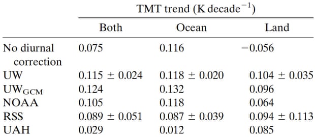
On the other hand, different groups processing the same raw satellite data arrive at very different estimates of the warming trend in the atmosphere. By this criterion, again, surface temperatures beat satellites. As Carl Mears has said,
I consider [surface temperature datasets] to be more reliable than satellite datasets (they certainly agree with each other better than the various satellite datasets do!).
Tropical mid-troposphere temperature satellite trend estimates from different groups using different diurnal drift correction approaches. From Po-Chedley et al. (2014).

Maybe we consider it important to measure how much humans are warming the entire planet. Only about 2% of the heat trapped by increased greenhouse effect goes into warming the atmosphere; over 90% goes into warming the oceans. By that criterion, ocean heat content data would be “the best;” far better than satellite data.
One benefit noted by proponents of the satellite data is that it’s validated by weather balloons directly measuring the temperature of the atmosphere. The problem is, the weather balloons indicate that the lower atmosphere has continued to warm in recent years, diverging from the satellite synthetic temperature estimates. That’s not much of an argument in favor of the satellite data.

Estimates of the temperature of the lower troposphere from satellites by RSS vs. weather balloons by NOAA (RATPAC). Created by Tamino at the Open Mind blog.
In fact, the weather balloon data debunks the “no significant warming since 1998” myth that motivates contrarians like Cruz to cherry pick the satellite data in the first place. It’s also worth noting this myth is based on über cherry picking.
So, the surface temperature data are “best” if you value the least uncertain temperature measurements, of the part of the planet where people live, with consistent results among different groups. The ocean heat data content are “best” if you want the most comprehensive measurement of the warming of the Earth.
The satellite data are best … if you want the data that show the least warming.
As Carl Mears notes starting at the 7:35 mark in the above video,
Posted by dana1981 on Monday, 18 January, 2016
 |
The Skeptical Science website by Skeptical Science is licensed under a Creative Commons Attribution 3.0 Unported License. |