Climate Science Glossary

Term Lookup

Enter a term in the search box to find its definition.

Settings

Use the controls in the far right panel to increase or decrease the number of terms automatically displayed (or to completely turn that feature off).

Term Lookup

Settings


All IPCC definitions taken from Climate Change 2007: The Physical Science Basis. Working Group I Contribution to the Fourth Assessment Report of the Intergovernmental Panel on Climate Change, Annex I, Glossary, pp. 941-954. Cambridge University Press.

Home Arguments Software Resources Comments The Consensus Project Translations About Support

Bluesky Facebook LinkedIn Mastodon MeWe

Twitter YouTube RSS Posts RSS Comments Email Subscribe


Climate's changed before
It's the sun
It's not bad
There is no consensus
It's cooling
Models are unreliable
Temp record is unreliable
Animals and plants can adapt
It hasn't warmed since 1998
Antarctica is gaining ice
View All Arguments...


Username
Password
New? Register here
Forgot your password?

Latest Posts

Archives

Arctic sea ice melt - natural or man-made?

Posted on 9 June 2008 by John Cook

Arctic sea ice has declined steadily since the 1970s. However, the 2007 summer saw a dramatic drop in sea ice extent, smashing the previous record minimum set in 2005 by 20%. This has been widely cited as proof of global warming. However, a popular mantra by climatologists is not to read too much into short term fluctuations - climate change is more concerned with long term trends. So how much of Arctic melt is due to natural variability and how much was a result of global warming?

The long term trend in Arctic sea ice

Global warming affects Arctic sea ice in various ways. Warming air temperatures have been observed over the past 3 decades by drifting buoys and radiometer satellites (Rigor 2000, Comiso 2003). Downward longwave radiation has increased, as expected when air temperature, water vapor and cloudiness increases (Francis 2006). More ocean heat is being transported into Arctic waters (Shimada 2006).

As sea ice melts, positive feedbacks enhance the rate of sea ice loss. Positive ice-albedo feedback has become a dominant factor since the mid-to-late 1990s (Perovich 2007). Older perennial ice is thicker and more likely to survive the summer melt season. It reflects more sunlight and transmits less solar radiation to the ocean. Satellite measurements have found over the past 3 decades, the amount of perennial sea ice has been steadily declining (Nghiem 2007). Consequently, the mean thickness of ice over the Arctic Ocean has thinned from 2.6 meters in March 1987 to 2.0 meters in 2007 (Stroeve 2008).


Global warming has a clearly observed, long term effect on Arctic sea ice. In fact, although climate models predict that Arctic sea ice will decline in response to greenhouse gas increases, the current pace of retreat at the end of the melt season is exceeding the models’ forecasts by around a factor of 3 (Stroeve 2007).
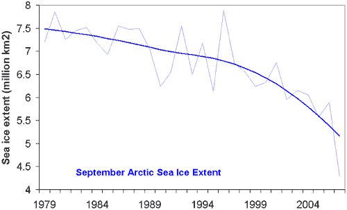


Figure 1: September Arctic Sea Ice Extent (thin, light blue) with long term trend (thick, dark blue). Sea ice extent is defined as the surface area enclosed by the sea ice edge (where sea ice concentration falls below 15%).

What caused the dramatic ice loss in 2007?

The sudden drop in sea ice extent in 2007 exceeded most expectations. The summer sea ice extent was 40% below 1980's levels and 20% below the previous record minimum set in 2005. The major factor in the 2007 melt was anomalous weather conditions.

An anticyclonic pattern formed in early June 2007 over the central Arctic Ocean, persisting for 3 months (Gascard 2008). This was coupled with low pressures over central and western Siberia. Persistent southerly winds between the high and low pressure centers gave rise to warmer air temperatures north of Siberia that promoted melt. The wind also transported ice away from the Siberian coast.

In addition, skies under the anticyclone were predominantly clear. The reduced cloudiness meant more than usual sunlight reached the sea ice, fostering strong sea ice melt (Kay 2008).

Both the wind patterns and reduced cloudliness were anomalies but not unprecedented. Similar patterns occurred in 1987 and 1977. However, past occurances didn't have the same dramatic effect as in 2007. The reason for the severe ice loss in 2007 was because the ice pack had suffered two decades of thinning and area reduction, making the sea ice more vulnerable to current weather conditions (Nghiem 2007).

Conclusion

Recent discussion about ocean cycles have focused on how internal variability can slow down global warming. The 2007 Arctic melt is a sobering example of the impact when internal variability enhances the long term global warming trend.

0 0

Printable Version  |  Link to this page

Comments

Prev  1  2  3  4  5  6  7  8  9  10  11  Next

Comments 251 to 300 out of 529:

  1. Re #240 Mizimi As Philippe has already indicated, you've posted links to a series of either non-science "sources", or have misinterpreted the science sources you've sourced. For example, on the effects of greenhouse gas emissions on plant growth and CO2 sequestration by the terrestrial environment, it's very clear that the massively enhanced CO2 emissions, especially during the last 30-odd years have decidedly NOT seen enhanced terrestrial absorption via enhanced plant growth as any sort of mitigation of our massive CO2 emissions. The reasons are very clear, and one of them is indicated in the very article you linked to: (i) There is a straightforward limit to the extent to which enhanced CO2 results in enhanced CO2 sequestration, as a result of many factors (e.g. nutrient and water availibility in the real world). As author of the "co2 effect on trees" article you linked to, states: "However, the scientists who conducted the study said such high growth rates probably will not be sustained as the experiment continues. They emphasized that the results do not indicate that more lush plant growth would soak up much of the extra CO2 entering the atmosphere from fossil fuel burning." (ii) In fact rather that the terrestrial environment, by far the main "sink" for atmospheric CO2 sequestration is the oceans. However, these are increasingly less efficient in absorbing enhanced atmospheric CO2 as CO2 levels rise, first because the ocean surface tends to saturate as atmospheric CO2 concentrations rise (Le Chatalier's principle), and secondly because, as the oceans warm, they become less effective sinks for CO2 (since warm water absorbs less dissolved CO2 than cold water). (iii) Third. because as the world warms, CO2 sequestration by the terrestrial environment actually tends to decrease. This has been shown, for example, in a paper published last week in Nature: "Prolonged suppression of ecosystem carbon dioxide uptake after an anomalously warm year" John A. Arnone et al (2008) Nature 455, 383-386. Abstract: "Terrestrial ecosystems control carbon dioxide fluxes to and from the atmosphere1, 2 through photosynthesis and respiration, a balance between net primary productivity and heterotrophic respiration, that determines whether an ecosystem is sequestering carbon or releasing it to the atmosphere. Global1, 3, 4, 5 and site-specific6 data sets have demonstrated that climate and climate variability influence biogeochemical processes that determine net ecosystem carbon dioxide exchange (NEE) at multiple timescales. Experimental data necessary to quantify impacts of a single climate variable, such as temperature anomalies, on NEE and carbon sequestration of ecosystems at interannual timescales have been lacking. This derives from an inability of field studies to avoid the confounding effects of natural intra-annual and interannual variability in temperature and precipitation. Here we present results from a four-year study using replicate 12,000-kg intact tallgrass prairie monoliths located in four 184-m3 enclosed lysimeters7. We exposed 6 of 12 monoliths to an anomalously warm year in the second year of the study8 and continuously quantified rates of ecosystem processes, including NEE. We find that warming decreases NEE in both the extreme year and the following year by inducing drought that suppresses net primary productivity in the extreme year and by stimulating heterotrophic respiration of soil biota in the subsequent year. Our data indicate that two years are required for NEE in the previously warmed experimental ecosystems to recover to levels measured in the control ecosystems. This time lag caused net ecosystem carbon sequestration in previously warmed ecosystems to be decreased threefold over the study period, compared with control ecosystems. Our findings suggest that more frequent anomalously warm years9, a possible consequence of increasing anthropogenic carbon dioxide levels10, may lead to a sustained decrease in carbon dioxide uptake by terrestrial ecosystems." (iv) And of course we can cast aside "wishful thinking" notions of enhanced plant sequestration as a mitigation of our massive greenhouse gas emissions, by the simple expedient of observing the atmospheric CO2 concentratrions. If these were being reduced by plant sequestration, one might expect greenhouse gas levels to be tailing off or decreasing. In fact they're INCREASING at a rather rapid rate (faster than linear, much in line with our emissions).
    0 0
  2. Re #223 Mizimi This doesn't make any sense: ["In any event, melting sea ice = drop in ocean temp - more biomass (plankton like it cool) = more sequestration of CO2 and so we go round again. The system as a whole has numerous ways to address imbalances as it has (successfully)in the past."] No...and one can't make up fanciful, simplistic and physically-unviable ladybird book notions as explanations of real world phenomena. Global warming results in WARMING of the oceans AND MELTING of land ice (mountain glacial and ice sheet ice). If you think that warming-induced melting of land ice results in ocean cooling and more biomass and sequestration of CO2, then you are sorely deluded (or just haven't bothered to think properly). Have a think about what processes occurred during the last glacial to interglacial transition as a result of enhanced absorption of solar energy due to Milankovitch cycles, for example. You'll find that the massive amounts of land ice melt (enough to raise sea levels by over 100 metres) during the last glacial to (our present) interglacial transition, 20,000-8000 years ago was accompanied by a warming of the oceans. Let's not pretend that we don't know what we do know. Notice that the "system" doesn't really "have numerous ways to address imbalances". The "system" responds to imbalances in the global heat budget (e.g. by changes in direct solar insolation or enhanced greenhouse gas concentrations) by settling towards a new equilibrium temperature. We can see this very clearly by addressing what has happened in the past. That's the problem. There's no evidence that the Earth has any particular "self-regulating" properties outwith the massive thermal intertial provided by the oceans. So as solar insolation (Milankovitch-induced) or greenhouse gas concentrations increases, so does the Earth's temperature.
    0 0
  3. Since some are also wondering where the "increase" (0.2% in extent) of Antarctic sea ice comes from, this is interesting: Author(s): Zhang JL Source: JOURNAL OF CLIMATE Volume: 20 Issue: 11 Pages: 2515-2529 Published: JUN 1 2007 Times Cited: 1 References: 34 Abstract: Estimates of sea ice extent based on satellite observations show an increasing Antarctic sea ice cover from 1979 to 2004 even though in situ observations show a prevailing warming trend in both the atmosphere and the ocean. This riddle is explored here using a global multicategory thickness and enthalpy distribution sea ice model coupled to an ocean model. Forced by the NCEP-NCAR reanalysis data, the model simulates an increase of 0.20 x 10(12) m(3) yr(-1) (1.0% yr(-1)) in total Antarctic sea ice volume and 0.084 x 10(12) m(2) yr(-1) (0.6% yr(-1)) in sea ice extent from 1979 to 2004 when the satellite observations show an increase of 0.027 x 10(12) m(2) yr(-1) (0.2% yr(-1)) in sea ice extent during the same period. The model shows that an increase in surface air temperature and downward longwave radiation results in an increase in the upper-ocean temperature and a decrease in sea ice growth, leading to a decrease in salt rejection from ice, in the upper-ocean salinity, and in the upper-ocean density. The reduced salt rejection and upper-ocean density and the enhanced thermohaline stratification tend to suppress convective overturning, leading to a decrease in the upward ocean heat transport and the ocean heat flux available to melt sea ice. The ice melting from ocean heat flux decreases faster than the ice growth does in the weakly stratified Southern Ocean, leading to an increase in the net ice production and hence an increase in ice mass. This mechanism is the main reason why the Antarctic sea ice has increased in spite of warming conditions both above and below during the period 1979-2004 and the extended period 1948-2004.
    0 0
  4. Philippe Re: 253: Interesting. Thanks.
    0 0
  5. Phillipe: "Mizimi, your equation melting ice=colder ocean does not quite work out. Melting ice means no albedo and increased absorbtion of solar energy by the Arctic ocean, leading to higher ocean temp. Arctic biomass does not like it." I disagree; albedo is a function of colour and area: ice melt runoff and edge melt both have a cooling effect without substantially affecting area. The report at: http://www.imr.no/arctic/cruise_diary/phytoplankton_bloom_on_spitzbergen_bank places the low sea temperature and high level of bloom down to the effects of ice melt. "Later that day we moved closer to the ice edge and took an additional two Large Stations in waters with temperatures below zero. The first was in the area of highest fluorescence (i.e. largest phytoplankton bloom) based on the CTD transect taken earlier. It also corresponded to the area of lowest salinity, no doubt produced by ice melt and provided the necessary stratification to initiate the phytoplankton bloom.In contrast to the first two Large Stations there were many more copepods, mostly Calanus glacialis but also some C. hyperboreus which are indicative of Arctic Water. These copepods were feeding on the phytoplankton bloom. " With respect to the downturn in krill I have (at present)no definitive information: Googling 'krill' mostly lists a large number of sites claiming that overfishing of krill for commercial products is a major cause. Regarding biomass response to increasing CO2 levels - I make no assertions that biomass will respond radically in a short period of time. Sequestration by trees is a lengthy process, less so for woody shrubs etc. I repeat: commercial growers have proven there is a large response for CO2 concentrations up to 1000ppm (all other requirements being adequate).
    0 0
  6. Phillipe: #253 I echo QM's comment; thanks also. I wonder what limitations there are to this effect..if any? On Krill: An article suggesting GW is the cause thro' loss of sea ice is countered by another pointing to the decline in blue whale numbers ( the whales provide iron through their excrement which is essential for the plankton) and another that challenges the data supporting the hypothesis. Another study shows krill at ocean depths well below that expected which suggests krill numbers may be higher than supposed. http://www.worldclimatereport.com/index.php/2004/11/11/krill-the-messenger/ http://www.asoc.org/Portals/0/decline%20of%20whales%20decline%20krill.pdf http://www.physorg.com/news123165274.html http://www.ccamlr.org/pu/e/sc/fish-monit/hs-krill.htm krill limits http://uplink.space.com/showflat.php?Cat=&Board=sciastro&Number=45459&page=1&view=collapsed&sb=3&o=0&fpart=
    0 0
  7. Rising Arctic Storm Activity Sways Sea Ice, Climate ScienceDaily (Oct. 6, 2008) — A new NASA study shows that the rising frequency and intensity of arctic storms over the last half century, attributed to progressively warmer waters, directly provoked acceleration of the rate of arctic sea ice drift, long considered by scientists as a bellwether of climate change.
    0 0
  8. (continued from comments 96 - 104, and perhaps 95, at "It's volcanoes (or lack thereof)") 1. 'solar dimming/brightenning' - I'm not sure what terms are used for what exactly here, but this is confusing, because it sounds like one is discussing solar TSI changes, when it was intended to discuss global dimming - the reduction in solar radiation reaching the surface. Global brightenning might not even be the opposite of that - I could imagine global brightenning might be used to refer to an incress in albedo as seen from TOA (top of atmosphere) - PS hypothetically if this occurs it could be seen on the dark portion of the moon - Earthshine reflecting off the moon's night side. I don't know if there are any observations indicating a trend in that or not. 2. Quietman 87: "Fire under the ice International expedition discovers gigantic volcanic eruption in the Arctic Ocean" http://www.eurekalert.org/pub_releases/2008-06/haog-fut062508.php You should post that website under "It's volcanoes"... - it's the first I've seen with actual evidence of a change in volcanism. However, the changes are still just on the scale of individual eruptions - Whether the the lack of knowlegde of prior such eruptions is an actual knowledge of a lack of prior such eruptions depends on whether it could have been expected to be noticed or missed - in this case I am very skeptical that there is any evidence at all of a trend here. And even if there were, I am very skeptical it could account for any significant portion of climate change, even regionally (consider the numbers - the actual geothermal heat output of an eruption compared to the actual heat going into the ocean - and by the way, remember that the global average geothermal heat flux at the surface is a little under 0.1 W/m2, and most of that is just thermal conduction through a temperature gradient in solid rock (and groundwater, but in most areas I don't think it's sufficient to drive groundwater convection?? or that groundwater flow is fast enough to cause rapid changes), with radioactive heat contributions - nothing that could change fast, except maybe where there's fast-flowing groundwater or hydrothermal vents, and how fast could those change on what timescales...?). 3. Notice in Quietman 107: "Surface warming by the solar cycle as revealed by the composite mean difference projection" "Charles D. Camp and Ka Kit Tung Received 29 March 2007; revised 15 May 2007; accepted 14 June 2007; published 18 July 2007. Geophys. Res. Lett., 34, L14703, doi:10.1029/2007GL030207." " [12] We will argue in a separate paper that the observed warming is caused mostly by the radiative heating (TSI minus the 15% absorbed by ozone in the stratosphere), when taking into account the positive climate feedbacks (a factor of 2?3) also expected for the greenhouse warming problem. " I haven't seen it myself but it sounds like they've found some reason to think that it is indeed solar TSI forcing at the tropopause (or nearly that) and not some aspect of solar forcing that wouldn't apply to GHGs - perhaps a difference in timing between TSI and solar wind variations, etc.? 0. Quietman 151: "The lies come from both deniers and alarmists, those of us who are skeptical do not need to lie, we simply ask for proof of your hypothesis. Make a prediction that pans out for a change, just once, and you will convince us skeptics. So far it's a no hitter. " Just once? To repeat from above, stratospheric cooling (with some qualifications because ozone depletion contributes, but there may be some spatial-temporal distinction there, and attributed proportions should be calculable - ie that ozone could only account for x, GHG's for y, etc..); increased warming of nights (the trend has not been constant but it's in there)... These two things would not be explained by solar forcing. The increased night warming could be explained by volcanic and anthropogenic aerosols if the forcing is sufficient - ie they do have the quality of cooling days more than nights... Add to that: Svante Arrhenius (spelling?) over 100 years ago (maybe 200?) predicted warming from CO2 increases. James Hansen 1988 - his graph for the forcing scenario most closely matched has thus far stayed close to the temperatures. And: Increased storm activity in the Arctic. Some other circulation changes - there may be evidence of expansion of the Hadley cell, for example. I think evidence of changes in rainfall patterns (space and time, etc.). And: greater warming in the Northern Hemisphere, with especially lower warming in the ocean around Antarctica and in the North Atlantic near Greenland (granted I'm not sure when these predictions were first made but at least for the first part (ocean around Antarctica), it's in a book from 1994. And: simple one-dimensional radiative-convective models from a few decades ago. And: extending the record back even farther with new data, the correlation between CO2 (and CH4) and climate continues. And: glaciers melting around the world - not just Greenland, not just Arctic sea ice, not just Kilomanjaro - and among other tropical glaciers, evidence that it is unusual in the last several thousand years (- that the ice is that old, in other words - yes, ice can flow, but there are some details - that for example, in the ice core, no evidence of melt going back x years, and then the team returns to the site and they find the ice is melting... something like that). And: sea level rising. ocean heat content increasing (that and a number of other things above argue against this all being urban heat islands - that and maybe also the lack of warming in SE U.S. - after all, there are cities there, aren't there - or have they not been growing as fast as other urban areas?). And: both the observations and the theory are a bit unclear on this one, but it does seem like tropical cyclones have been getting more intense - if not more numerous (outside the Atlantic multidecadal cycle)... to be continued...
    0 0
  9. Patrick Re: Fire and Ice - Sorry, I should have. Re: Hansen's prediction - Off by 50%, He predicted exactly twice the warming that actually occurred.
    0 0
  10. I will try to reply to the rest when you finish your analysis. Sounds good so far.
    0 0
  11. Re #259 I'm skeptical about your comments re Hansen's forecast of global temperature change under the influence of enhanced greenhouse-induced warming. You suggest that "he predicted exactly twice the warming that actually occurred." Can you indicate how you come to that conclusion? I'm interested in the evidence that informs your opinion..
    0 0
  12. 0.1 (PS after a while you might figure out what these numbers meand): Attribution: To clarify: "Just once? To repeat from above, stratospheric cooling"... "increased warming of nights" ... I also noted that stratospheric ozone depletion could also qualitatively explain stratospheric cooling (and some amount of tropospheric+surface (TPSF for future reference) warming ), and that albedo cooling such as from aerosols (of the right mix) could also qualitatively explain a decrease in diurnal temperature ranges. One key there is 'qualitatively' - for attribution, one would want the numbers. If one expects x degrees change from forcing A and y degrees change from forcing B, then one might start by looking at z/(x+y), where z is the observed change, and attribute z proportionately. One then may need to adjust that if there is some reason to suspect that the relative error in modeling/calculating is different for x and for y. If x can be modelled with more confidence than y (***ie if for x relative to y, the physics are better understood, model resolution and sub-grid scale issues are less of a concern (such as if y depends more on a smaller part of the atmosphere in particular?), or if forcing A is better known than forcing B), then it may make more sense to asign a greater likely share of the theory-observation mismatch to y. However, it would be erroneous, without some reason to do so, to just assume that y was correct and x is off or vice versa. (PS this would also apply when unforced variability is thrown into the mix). The other key is that there may additional aspects that are different for the climatic response to each forcing (as similar solar and GHG forcing of TPSF temperatures have different effects on the stratosphere). For example, increased albedo of course has a cooling effect and can't by itself explain an average TPSF warming (and there could be more subtle differences among different albedo forcings - volcanic vs tropospheric vs land cover). Absorbing atmospheric brown clouds would tend to increase the diurnal temperature range of the air volume they occupy (but that's not much to begin with, away from the surface)but could decrease the surface range, so that would be a candidate. Of course, the horizontal variations of these various aerosols and land-cover matters are quite different and that opens up another avenue for distinguishing their effects. ... One could imagine some combination of solar forcing and aerosol forcing could result in warming with reduced daytime warming, but again, 1. How would the numbers work out exactly?, 2. Other effects - So far as I know no significant albedo enhancement exists that would cool the stratosphere (reflection from below and perhaps scattering from within (? and/or the nonzero absorptivity of even relatively reflective stratospheric aerosols) may tend to warm the stratosphere slightly - **** THEN again, some climate feedbacks themselves might cause some stratospheric cooling - decreased albedo at the surface, and water vapor and the LW (greenhouse) effect of clouds with sufficiently high tops - although an increase in albedo from increased cloud cover, except over or replacing snow and ice (PS clouds over snow and ice could in some cases reduce albedo, I think) would tend to warm the stratosphere for reasons described above... But there may be some horizontal variation fingerprints to these various processes... Well, there is yet another way to distinguish - seasonal variations - ozone has seasonal variations and anthropogenic changes to ozone has seasonal variations. The seasonal variations of solar and GHG forcings, etc, may also be different. The overall seasonal variations (and spatial variations) in climate response in TPSF may be too similar but perhaps some stratospheric responses might contain clues. Then of course, there's the thermosphere, which doesn't have much ozone (chemical equilibria favor atomic oxygen over ozone and at sufficient height over diatomic oxygen, actually) but has the opposite sign of response to solar and GHG forcing. There is also of course the longer term temporal variations - volcanic aerosols have distinct pulses, anthropogenic GHGs have steadily risen, anthropogenic aerosols have their own trend, solar, etc... this can get tricky because of the internal variability on those timescales, of course. To sum up, if you have n unknowns and m equations, you can solve for the unknowns if m = n. If m > n, then any random combination of equations may yield conficting results - mathematically they can't all be true; but - these equations aren't random - they're rooted in physics and must agree with each other. Uncertainty allows for some disagreement (the ranges of allowable values won't be identical, but using many equations would tend to reduce the resulting uncertainty in the unknowns (and perhaps would then feedback as knowlegdge about how to improve some of those equations). Science is putting together a puzzle; sometimes the puzzle pieces have fuzzy edges and they don't fit precisely but additional pieces can help decide which arrangement is most likely, etc... On internal variability - that will always make attribution a little difficult but refer back to above. If we understood the forced responses better than internal variability then it wouldn't make sense to assume any little wobble outside the expected range of variability would render our models incorrect with respect to a forced response - and certainly variations within the expected range of variability don't render models in error. 0. Quietman 259: "Re: Hansen's prediction - Off by 50%, He predicted exactly twice the warming that actually occurred." That's a common misunderstanding (which had been spread by Pat Michaels). A. http://www.columbia.edu/~jeh1/2005/Crichton_20050927.pdf B. http://sciencepolicy.colorado.edu/prometheus/archives/climate_change/000836evaluating_jim_hanse.html From the later: "Perhaps the errors cancel out, but an accurate prediction based on inaccurate assumptions should give some pause to using those same assumptions into the future." These errors are errors in emissions scenarios for different greenhouse gases. However, what matters to climate science, assuming similar efficacies of those GHGs, is the history of the sum of those forcings. From the earlier, in footnotes: " Climate sensitivity is usually expressed as the equilibrium global warming expected to result from doubling the amount of CO2 in the air. Empirical evidence from the Earth’s history indicates that climate sensitivity is about 3°C, with an uncertainty of about 1°C. A climate model yields its own sensitivity, based on the best physics that the users can incorporate at any given time. The 1988 GISS model sensitivity was 4.2°C, while it is 2.7°C for the 2005 model. It is suspected that the sensitivity of the 2005 model may be slightly too small because of the sea ice formulation being too stable. " I would guess then that running the same model from 1988 with the realized forcing history would produce a bit too much warming, but not so much more (assuming 2005 model is more accurate, (4.2-2.7)/2.7 = 1.5/2.7 = 5/9. Okay, that is just over 50 % error, BUT that is not twice the warming, that is just over 1.5 times the warming. And the last part of that footnote suggests the error may be a bit less than that.
    0 0
  13. Re #258 Patrick (in reference to your response to the Monty Python style "what did the Romans ever do to us" request in #151 for predictions "that pan out for a change"): The predictions of a greatly delayed response of the Antarctic to greenhouse-induced warming and a marked asymmetry of warming between the high Northern and high Southern latitudes, were made in 1981 by Schneider and Thompson, and in more detail by Bryan et al in 1988. Describing these early modelling predictions of a greatly reduced Antarctic warming compared to predicted enhanced warming in the high Northern latitudes, Manabe and Stouffer state [in their recent review: Role of Ocean in Global Warming; J. Meterolog. Soc. Jpn. 85B 385-403.(2007)]: [“They [Bryan 1988] found that the increase in surface temperature is very small in the Circumpolar Ocean of the Southern Hemisphere in contrast to high latitudes of the Northern Hemisphere where the increase is relatively large.”] In other words the very marked asymmetry between the marked warming of the high Norther latitudes, compared to the very small expected warming in the deep S. hemisphere was predicted at least 20 years ago. I've outlined this in more detail in my post # 66 on this thread. Some other examples (of quite a large number in addition to your examples) in which climate predictions from calculations and modelling have turned out to be prescient (i.e. reality has subsequently matched the models): In addition to Hansen's rather good prediction of greenhouse gas warming from models set up and run from the early 1980's it's worth pointing out that already in 1975, Wallace Broecker was calculating (i.e. modelling) the warming expected in the future from continuing increases in greenhouse gas emissions: In his paper: Broecker, WS (1975) “Climate Change: Are we on the brink of a pronounced global warming? Science 189, 460-463 Broecker says (referring initially to the small N. hemisphere cooling observed in then-recent times): "...This cooling has, over the last three decades, more than compensated for the warming effect produced by the CO2 released into the atmosphere as a by-product of chemical fuel combustion. By analogy with similar events in the past, the present natural cooling will, however, bottom out during the next decade or so. Once this happens, the CO2 effect will tend to become a significant factor and by the first decade of the next century we may experience global temperatures warmer than any in the last 1000 years….” Broecker then goes on to describe predictive modelling of anthropogenic CO2-induced warming, taking account known levels of CO2 emissions from the UN and a projection (3% per year) of the increase in emissions, the best estimates from measurements of the emitted CO2 sequestered in the oceans and the terrestrial environment and the known warming properties of atmospheric CO2. His modelling came up with the following prediction. The Earths temperature in 2000 would be around 0.9 oC warmer than the 1900 baseline temperature. The Earth is around 0.8 oC warmer now than it was at the start of the 20th century. Not a bad prediction. Why was his prediction so good? I expect he was partly lucky since the strengths of the various contributions to climate were not so well known then as now. But, basically he was about right because the effects of atmospheric CO2 in causing warming of the Earth via the greenhouse effect were well known and easily calculated. Two other related examples of the rather strong predictive power of climate and atmospheric modelling are interesting, since in each case the predictions initially semed like they might not accord well with reality (and in the first case was strongly argued against by at least one prominent scientist) ONE: Atmospheric greenhouse theory, incorported into climate models predict/ed that as the atmosphere warms in response to raised CO2, so the atmospheric water vapour levels would rise. This prediction was strongly opposed by a very few scientists, most notably Richard Lindzen, who asserted that the troposphere would dry in response to raised CO2 levels providing a negative feedback. In fact the data eventually showed that the presictions from models were correct [see Soden et al (2005); Brogniez H and Pierrehumbert RT (2007); Santer BD et al. (2007); Buehler et al. (2008); Gettelman and Fu (2008)…and so on (citations below]. An example where a major prediction from modeling was contested, but the models were subsequently vindicated by real world measurements. TWO: Atmospheric greenhouse theory incorporated into climate models predict/ed that the troposphere should warm relative to the surface. Early tropospheric temperature measures seemed to contradict this prediction. However it turned out in time that errors in tropospheric temperature measures were responsible for the discrepancy and by 2006 the U.S. Climate Change Science Program (CCSP) who investigated this issue stated that there is ‘no significant discrepancy’ between surface and tropospheric warming, consistent with model results (Karl et al., 2006). However there has still remained a potential discrepancy between model predictions and tropospherical temperature measurements in the tropics. However recent work has again shown that the errors likely lie in the temperature measures (largely radionsides/weather balloons) [see Sherwood (2005); Thorne (2007); McCarthy (2008); Haimburger (2008)], and again it appears that the predictions from the models have turned out to be correct (Santer et al 2008). B. D. Santer et al. (2008) Consistency of modelled and observed temperature trends in the tropical troposphere. International Journal of Climatology 28, 1703 – 1722. ------------------------- Brogniez H and Pierrehumbert RT (2007) Intercomparison of tropical tropospheric humidity in GCMs with AMSU-B water vapor data. Geophys. Res. Lett. 34, art #L17912 Buehler SA (2008) An upper tropospheric humidity data set from operational satellite microwave data. J. Geophys. Res. 113, art #D14110 Gettelman A and Fu, Q. (2008) Observed and simulated upper-tropospheric water vapor feedback . J. Climate 21, 3282-3289 Santer BD et al. (2007) Identification of human-induced changes in atmospheric moisture content. Proc. Natl. Acad. Sci. USA 104, 15248-15253 Soden BJ, et al (2005) The radiative signature of upper tropospheric moistening Science 310, 841-844. ----------------- S. C. Sherwood et al. (2005) Radiosonde Daytime Biases and Late-20th Century Warming Science 309, 1556 – 1559. L. Haimberger et al (2008) Toward Elimination of the Warm Bias in Historic Radiosonde Temperature Records—Some New Results from a Comprehensive Intercomparison of Upper-Air Data. J. Climate 21, 4587-4606. M. P. McCarthy et al. (2008) “Assessing Bias and Uncertainty in the HadAT-Adjusted Radiosonde Climate Record”. J. Climate 21, 817-832. P. W. Thorne et al. (2007) Tropical vertical temperature trends: A real discrepancy? Geophys. Res. Lett. 34, L16702. ---------------- Karl TR, Hassol SJ, Miller CD, Murray WL (eds). 2006. Temperature Trends in the Lower Atmosphere: Steps for Understanding and Reconciling Differences. A Report by the U.S. Climate Change Science Program and the Subcommittee on Global Change Research. National Oceanic and Atmospheric Administration, National Climatic Data Center: Asheville, NC; 164.
    0 0
  14. Re Quietman 259/151 You might be interested in reading my post #263, since it was you (your post #151) who initially questioned the predictive powers of modelling. In addition to Patricks examples, the examples in post #263 document pretty unequivocably that: ONE: the marked asymmetry between Arctic warming (it was predicted to warm a lot) and Antarctic warming (very little in the early stages of greenhouse waming), was predicted already in the early-mid 1980's TWO: That the extent of warming by the year 2000 was predicted rather accurately in 1975 by Wallace Broecker THREE: Hansen's models set up in the early 1980's have done a good job in predicting the temperature rise in the subsequent 20 years (notwithstanding various efforts to trash this work-see Patrick's post #262!) FOUR: Model predictions of enhanced tropospheric moistening were shown to be correct despite strenuous efforts by at least one prominent scientist to suggest that the models would be wrong. FIVE: Model predictions of enhanced tropospheric warming were eventually vindicated despite apparent discrepencies with real world measurements, the latter turning out to have been incorrect. So climate modelling has done a pretty good job so far of predicting multiple effects of massive enhancement ofr atmospheric greenhouse gas levels.
    0 0
  15. Patrick On the double error you are right, I repeated what I read and should have known better since it is not a linear response. I apologise for repeating the error. I don't remember where I read it now as it was about a year ago. chris Re: 263 - I was aware of this and agree. Re: models - I posted a link to an article from 2007, I think october, on model accuracy/inaccuracy in the appropriate thread here under the "arguments" heading a while back. As far as I am aware your point FIVE is the opinion expressed on Real Climate but I have not seen it on any other web site, and as you know I do not trust that site. Too much of an agenda there.
    0 0
  16. Re #265 Quietman, the reassessment of tropospheric temperature measurements, especially those over the tropics, were the results of the efforts of a large number of scientists who identified artifacts especially in the radiosonde readings. This work is very widely published in the scientific literature (several of the relevant papers highlighting the radiosonde errors are listed in my post #263, just above). The resolution of apparent disparities between models and tropospheric emperatues has been widely resolved (see report of the Report by the U.S. Climate Change Science Program and the Subcommittee on Global Change Research cited in my post #263)....the more specific resolution of apparent disparities in the tropical data is described in this paper: B. D. Santer et al. (2008) Consistency of modelled and observed temperature trends in the tropical troposphere. International Journal of Climatology 28, 1703 – 1722. None of this has any particular relationship to Real Climate (where did you get that idea?). It's widely verifed research from a large number of different sources published in the scientific literature. So nothing to do with Real Climate, but everything to do with careful science published widely in the scientific literature!
    0 0
  17. To clarify - just to be clear, while I mentioned that some feedbacks to any warming should tend to cool the stratosphere - although others may warm it - my understanding is that the expectation of warming stratosphere from positive solar solar forcing and cooling stratosphere from positive GHG forcing both include the expected feedbacks. Of course, feedbacks won't be exactly as expected, but the individual feedback components might be observed and their effects calculated and compared to the model feedback effects, etc... (I don't know if that's really been done or not or how much). Summarizing the gist of all that - while feedbacks have uncertainties, the forcing mechanism and amount is well understood for GHGs, solar TSI (maybe a bit more uncertainty with amount), and volcanic aerosols. Anthropogenic aerosols have more uncertainty. One could make a list of dark horse candidates (PDO-ENSO cloud feedback (as in Spencer) greatly magnifying internal variability, tidal forcing - oceanic effects, geothermal variations, geomagnetism and non-TSI or non-UV solar forcing) - for some of these, a potential for a mechanism can be identified, though at least for me there is skepticism that the magnitude of the effect could be significant; for others, mechanisms can be imagined but there is a lack of information about their reality (to my knowledge). For others, there may be enough information already to rule out any significant contribution at least to the recent climate change on the AGW-relevant time-scale. Or some middle ground among those three conditions may apply. (I did my best to reason through some of this in "It's volcanoes"...) One thing these (those with potential, anyway) all have in common, to varying degrees, is greater uncertainty regarding any potential significance. This is in addition to any climate feedbacks, so without some specific reason to the contrary, there is greater uncertainty with these than with the more 'established' climate forcings. Note that it generally makes more sense to use what is known to shed light upon the unknown (ie that using what we know, we either can or can't explain observations/data, to whatever degree; therefore it is less likely or more likely, to whatever degree, that something we haven't accounted for is important after all) than it does to take the potential for importance of unknowns to find error in what was thought to be known.
    0 0
  18. (PS thanks, chris) ... Just for insight's sake: Two other dark horse candidates: 1. solar eclipse frequency and spatical distribution changes. 2. Changes in 'moonshine' (averaged over the lunar month) or variations in 'moonshine' (changes in lunar cycle) Both these being due to variations in the orbits of the Earth around the sun and moon about the Earth. Of course, without even bothering with explicit calculations, I would rule these out off the bat as significant to climate variations on just about any timescale - with one intriguing caveat: I wonder what effect these (and the tides) might have had in the first several millions (? - unsure of how fast the moon receded) of years of Earth's history (after the moon-forming impact, of-course - and some cooling; I doubt it would be of much significance to climate over a magma ocean!).
    0 0
  19. Patrick Thank you for your thoughts on this. Quite logical and I agree with your summation.
    0 0
  20. chris Sorry, I had been discussing Hansen and RC with Phillipe and Patrick and got confused. Chalk it up to a senile moment.
    0 0
  21. 0.2 - models This is only tangentially related, but it has been argued that evidence exists for solar forcing on other planets. This isn't a very strong argument. What's ironic is - from the little I've read about it - the argument that Jupiter's climate is changing - it's ironic because the changes that have occured seem to be a form of internal variability, and may have been predicted by a computer model! (Now I'm going to another part of this website to double check that.)
    0 0
  22. Re Quietman 4 (links): 10. "Evidence mounts for Arctic Oscillation's impact on northern climate" http://www.washington.edu/newsroom/news/1999archive/12-99archive/k121699.html "The Arctic Oscillation is a seesaw pattern in which atmospheric pressure at polar and middle latitudes fluctuates between positive and negative phases. The negative phase brings higher-than-normal pressure over the polar region and lower-than-normal pressure at about 45 degrees north latitude. The positive phase brings the opposite conditions, steering ocean storms farther north and bringing wetter weather to Alaska, Scotland and Scandinavia and drier conditions to areas such as California, Spain and the Middle East. In recent years the Arctic Oscillation has been mostly in its positive phase, research has shown. "In its positive phase," Thompson said, "frigid winter air doesn't plunge as far south into North America," meaning warmer winters for much of the United States east of the Rocky Mountains, while areas such as Greenland and Newfoundland tend to be colder than normal." ... "Stratosphere cooling in the last few decades has caused the counterclockwise circulation around the North Pole to strengthen in winter. In turn, the belt of westerly winds at the surface along 45 degrees north latitude has shifted farther north, the scientists said, sweeping larger quantities of mild ocean air across Scandinavia and Russia and bringing balmier winters over most of the United States as well." The Arctic Oscillation is an alternate view of what many scientists call the North Atlantic Oscillation, the researchers said. Year-to-year fluctuations in the North Atlantic Oscillation are thought to be prompted primarily by changes in the ocean, as with El Niño. However, Wallace, Thompson and Baldwin argue that the North Atlantic Oscillation is in fact part of the Arctic Oscillation, which involves atmospheric circulation in the entire hemisphere. They say the trend toward a stronger, tighter circulation around the North Pole could be triggered just as well by processes in the stratosphere as by those in the ocean. The trend in the Arctic Oscillation, they said, has been reproduced in climate models with increasing concentrations of greenhouse gases." Very interesting. Presumably solar and volcanic forcings, etc. would also have effects on stratospheric temperatures and thus could also affect stratospheric-tropospheric interactions. I've read that current (AO)GCMs (computer climate models) don't resolve or have trouble resolving some circulation processes of the upper atmosphere. However there is no reason to suspect that increased knowledge about this will lead to a conclusion that significantly reduces anthropogenic forcings' roles relative to other things. (It sounds like, perhaps, the changes in tropospheric circulation associated with AO (?) (Arctic Oscillation - same as NAM? - North(ern ...) Annular Mode ?) rearrange heat but don't directly result in a change in global average temperature by that - except of course, there could/will be feedbacks which might have some global average tendency one way or the other.) I'll have to look more into this. But a few quick notes for now: Increased/decreased horizontal temperature gradients increase/decrease vertical geostrophic wind shear - wind speed above increases/decrease or wind speed below does the opposite or both. Geostrophic winds in the stratosphere (and mesosphere, etc.) is affected by tropospheric conditions, and vice versa, as it is for parts of these. Wind direction is also potentially affected. Vertical motion can transport momentum. Perhaps less obviously but more importantly (?), interactions among various layers can transfer momentum vertically (vertical wind shear allows air to move into different conditions (as determined by the changing quality of air above and below) requiring it to accelerate in some way; the layers interact). Vertical interaction is generally reduced (at least for transient disturbances?) when stratification (vertical static stability) is greater - when temperature decreases with height less or increases with height more. (Imagine how much more intensive the mechanical interaction of ocean and atmosphere would be if the ocean were only 0.1 % of it's density.) 3. "Arctic Climate" http://nsidc.org/arcticmet/basics/arctic_climate.html "extreme solar radiation conditions" - This just refers to the seasonal extremes of insolation (At the pole, 6 months of darkness, 6 months of daylight with low sun angle, etc.).
    0 0
  23. 10. Some thoughts: Temperature changes at the surface and lower troposphere will have a radiative effect on the stratosphere. Especially when any intevening clouds or high water vapor concentrations are close enough to the surface, there will be a band of wavelengths in which the surface radiates up to the ozone layer. Since the high latitudes (northern hemisphere) warm more than the low latitudes, this will tend to warm the northern polar stratosphere more. However, the latitudinal trend is reversed in the upper troposphere, which will substitute radiation from below with it's own, to varying degrees, depending on wavelength, cloud top heights, etc. Yet, to begin with, I think the latitudinal trend is greater at lower than upper levels, and the increased greenhouse effect will shield the stratosphere more from the surface, and this would tend to warm the polar stratosphere more than the lower latitude stratosphere.** Increased solar UV should produce more ozone. Higher ozone concentrations would push the distribution of solar heating upward a bit. Relative to the local vertical distribution of ozone, solar heating (by UV) will be more concentrated toward higher levels at higher latitudes and in winter, because of the angle of the sun's rays (a longer path length fitting into the same vertical distance).
    0 0
  24. ... But also: ozone chemical reactions will be affected by temperature. Temperature affects circulation. Ozone affects temperature. Circulation affects temperature and ozone. The enhanced warming at low levels in high latitudes, is strongest in the colder months, and might actually be reversed (reduced warming relative to some other latitudes, at least over water (?)) in some portion of the summer or near that time.
    0 0
  25. Patrick Re: Ozone - Agreed Somewhere here there are links to papers on ozone that agree with what you said (I don't remember where).
    0 0
  26. Basic info on global circulation patterns: Troposphere: latitudinal variations in solar heating drive thermally direct Hadley cells - altered and enhanced by the role of water vapor: Widespread sinking over subtropics; adiabatic warming, radiative cooling. Rising in cumulus convection (hot towers) in the ITCZ - latent heating, adiabatic cooling. Seasonal Variation in forcing: ITCZ migrates north and south; the most intense Hadley cell is from the ITCZ to the winter subtropics. Seasonal land-sea contrasts: monsoons, enhanced by water vapor (latent heating). Also, Walker Circulation. Hurricanes, cumulus convection, land-sea breezes and mountain-valley breezes. -- Baroclinic instability in midlatitudes: Eddies carry heat polewards, concentrate zonal (westerly) momentum from north and south, transfer zonal momentum downwards to surface. Drives a thermally-indirect Ferrel Cell. -- Stratosphere and Mesosphere: Radiative equilibrium would be a temperature maximum around stratopause, Latitinal variation is - in lower stratosphere, warmest on the summer-side of the equator, but still cooler at summer pole; going up, latitude of greatest temperatures shifts all the way to summer polar region (happens while still in stratosphere). Winter polar region very cold. Circulations driven by propagation of mechanical energy upward from troposphere drive stratospheric and mesospheric motions that alter the temperature distribution: Quasi-stationary planetary waves produced in the troposphere can (under certain conditions) propagate upward - this can only happen with westerly winds with certain ranges of speeds - this happens in winter; not in summer. In winter, planetary waves propagate upward and dissipate in the stratosphere, which drives poleward motion; BREWER-DOBSON circulation in the stratosphere is upward over tropics, poleward into the winter hemisphere, and downward at higher latitudes. This warms the mid and high-latitude lower stratosphere and cools the tropical tropopause. Sometimes this happens in bursts called 'sudden stratospheric warmings'. But on average the winter polar stratosphere is still colder than the winter midlatitude stratosphere. Some gravity waves produced in the troposphere can propagate up to the mesosphere where they are dissipated, driving motion that is from the summer hemisphere to the winter hemisphere, with upward motion over the summer high latitudes and downward motion over the winter high latitudes. This cools the summer upper mesosphere and warms the winter mesosphere. Thus on average: At tropopause, coldest over tropics (the tropopause is highest over the tropics). In the lower stratosphere, summer polar region is warmer, tropics are colder, midlatitude winter is a bit warmer again, but the polar winter is colder. Higher in the stratosphere, there is a general decline in temperature from summer pole to winter pole. This continues somewhat into the mesosphere, except starting in the lower mesosphere winter high latitudes, the temperature gradient reverses; going up this condition spreads across the tropics and all the way to the summer pole, so that in the upper mesosphere and mesopause region, the summer pole is cold and the winter pole is warmer.
    0 0
  27. Characteristics of the atmosphere can be divided into a mean state (as in zonal mean - averaged over all longitudes) and eddies. Eddy winds blow north and south, east and west; average of eddy wind velocity would be zero (unless...?). Eddy thermal anomalies are warm and cold; average is zero. But correlation can exist so that the average eddy heat and momentum fluxes are nonzero. These eddies are waves. They can propagate. They can be 'emitted' (generated, grow), can be reflected, can be absorbed, depending on the type of wave and conditions of the atmosphere.
    0 0
  28. Patrick Re: 276 I am just guessing but doesn't direct nonstop sunlight on the poles during a 6 month long day have a little to do with this? Re: 277 I have no clue as to what that means. Are you talking about wind or radiation? Eddys are circular currents caused by turbulence (in water or air) so I do not follow.
    0 0
  29. "Re: 276 I am just guessing but doesn't direct nonstop sunlight on the poles during a 6 month long day have a little to do with this?" YES! (And that will bear on any changes in solar forcing, but in and of itself is just part of the regular seasonal cycle which changes on timescales of several thousand years and longer...) "Re: 277 I have no clue as to what that means. Are you talking about wind or radiation? Eddys are circular currents caused by turbulence (in water or air) so I do not follow. " Not about electromagnetic radiation as in photons. These are mechanical waves. Waves are often thought of as sinusoidal in some way, but one can have a single wave pulse. There's phase velocity and group velocity - for dispersive waves, not the same thing. (Energy propagates witht the group velocity.) In order for waves to occur there must be a restoring force - gravity, pressure, elasticity, etc... In the context of geophysical fluid dynamics, I'm not sure exactly if there is a distinction between eddies and waves. Eddies can propogate. Rossby waves involve rotation. Cyclones that develope in midlatitudes are an aspect of baroclinic waves, which I think may be considered a kind of Rossby wave... It is true that in order for baroclinic instability to occur, there must be some vertical level, called a critical level (or steering level in this case, for obvious reasons) where the wind averaged across the baroclinic wave (a basic state wind) is equal to the velocity of the motion of the baroclinic wave (at least in the case where the average wind is not changing direction with height); however, above and below, the wave is propagating through the air. Even if we ignore vertical motion, the air at the center of a cyclone is not necessarily going to be at the center of the same cyclone in the near future; Even if a cyclonic circulation is strictly two-dimensional and axisymmetric, so that at any instant the streamlines (parallel to the wind vector at each location) are circles, propagation of this streamline pattern can be such that individual trajectories spiral into and out of the cyclone and in some cases may curve anticyclonically. ... Often an analysis of the atmosphere is made using zonal averages - these are averages over all longitudes - so that they might be graphed in two dimensions (if averaged over some specific time period or at some particular moment in time, etc.). Then there are zonal means, mean temperature, zonal (westerly) wind, and the mean meridional circulation (north-south and up-down). Motions that average to zero are attributed to eddies. Correlations of some parts of eddies with other parts of eddies can yield nonzero eddy fluxes - for example, in this perspective, the average eddy temperature deviation is zero, the average eddy meridional wind velocity is zero, but the average of the product of the two can be nonzero - thus there is a nonzero northward temperature flux by eddies. The average zonal velocity of eddies can also be zero, but a correlation between eddy zonal wind velocity and eddy meridional wind velocity can yield a nonzero northward eddy flux of zonal (westerly) momentum. The average of the square of the eddy wind speed will be nonzero, and hence so will the eddy kinetic energy. One way of analyzing how eddies affect the mean is by looking at the EP flux, which is a mathematical expression derived from distributions of eddy temperature and momentum fluxes, and is related to the eddy potential vorticity flux. In this perspective, everything 'eddy' would include some of such things as (internal) gravity waves, (internal) intertia-gravity waves, Rossby waves (baroclinic waves, planetary waves, etc.), equatorial Rossby waves, Rossby-gravity waves, and Kelvin waves; thus these can all have eddy fluxes. I'm a bit vague on much of this, but the gist of what I've gotten is: These waves can propagate through the atmosphere in some ways; depending on the type and at least sometimes the wavelength of the wave, there can be a index of refraction assigned to parts of the atmosphere which is a function of the wind field, the coriolis effect (varies with latitude), stability, and/or quantities derived from those things - vorticity, potential vorticity, etc. Waves may propagate horizontally only or they may also propagate vertically. Relevant to either direction, there can be critical levels. There may be regions where the wave can not propogate in an oscillatory manner - upon reaching a boundary it may be felt on the other side as an evanescent wave, one which decays exponentially away from that boundary - if another boundary is reached where it can again propagate, perhaps some of it will have tunneled through the barier (perhaps analogous to electron tunneling, considering the quantum-mechanical wave nature of electrons; also perhaps analogous to the evanescent portion of an electromagnetic wave which exists on the opposite side of a reflecting surface). Some gravity waves are actually evanescent waves - for example, a gravity wave produced by wind blowing over a ridge may decay with height and have vertical phase planes vertical with - zero group velocity? - whereas otherwise a gravity wave produced by wind blowing over a ridge will propagate vertically (the energy will propagate with the group velocity, and this carries momentum). Waves may be concentrated by variations in the index of refraction. They may reflect. They may over-reflect - I'm not sure but maybe that's analogous to the stimulated emission of radiation. Generally, disturbances may radiate waves. Waves may grow, and thus must be taking something from the background state they inhabit. They may dissipate, and in doing so they may deposit momentum back into a background state. Waves can also break (like waves crashing on a beach). I started going into this because wave-mean interactions are important in the global circulation; wave propagation also is important in stratospheric and mesospheric motions; etc...
    0 0
  30. ... I think that - either when there is zero EP-flux or when the EP-flux divergence is zero?, then the wave is not dissipating (or amplifying or breaking) and so is not altering the mean state (it must be the first, because even without EP flux divergence, there is some alteration - but maybe it has to be reversed in time?). In such a case a wave can propagate by making only temporary changes (as electromagnetic waves may nudge the matter in a transparent material along the way (which affects how the wave propagates).
    0 0
  31. Patrick So you are saying that eddy waves are similar to eddy currents in electricity rather than in aerodynamics? Try to remember my background is engineering not climatology or theoretical physics.
    0 0
  32. "Try to remember my background is engineering not climatology or theoretical physics. " I have a little bit of engineering and basic physics background but I'm not sure exactly what you mean about eddy currents in electricity. However, I really haven't begun to explain how these mechanical waves propagate. So to correct that, here are two important examples: 1. Gravity waves exited by wind blowing over sinusoidal ridges. Take the (arbitrarily-defined) layer of air closest to the surface. Without wave-breaking, the air moves up and down over ridges. It thus has to accelerate. So there will be pressure variations. Take the next layer of air - because the first layer is displaced, the next layer must be displaced, etc. As a function of the wavelength of the ridges and the wind speed, there must be some frequency of oscillation for the air as it blows through this set-up. If the air is stable (potential temperature increasing with height), air displaced vertically will tend to fall back to where it was, and oscillate about an equilibrium level - in the absence of forcing, this continues except for thermal (radiative - photons) and mechanical dissipation of the potential and kinetic energy involved. This natural frequency is called the buoyancy frequency or Brunt-Vaisalla (sp?) frequency. If the forcing of gravity waves is at a higher frequency, (unless I have this backwards), then the gravity waves produced by wind blowing over ridges decrease exponentially with height; there is no vertical propagation of the energy. There is no form drag - that is, the pressure perturbations associated with the gravity waves are aligned with vertical displacement maxima and minima so that there is no sideways forcing. The dissipation that would occur is by viscosity, which would occur in the absence of gravity waves (wind blowing across the surface tends to lose momentum to the surface (and hence the Earth), and wind at different levels at different speeds can exchange momentum via viscosity, though that is not generally a dominant factor in atmospheric motions away from the surface). On the other hand, if the forcing frequency (determined by the wind and the wavelength of the ridges) is less, than ... to be continued...
    0 0
  33. ... well, now I'm not quite sure about the lack of form drag (the phase of pressure relative to displacement) with non-vertically propagating gravity waves, but anyway, moving on: If the forcing is at lower frequency than the buoyancy frequency, then: Vertical propagation occurs. surfaces of constant phase (crests and troughs) tilt with height. An interesting thing about these kinds of waves is that the group velocity is at right angles to the wave vector (which is perpendicular to the crests and troughs). The wave vector is in the direction of phase propagation. The group velocity is parallel to the crests and troughs. Relative to the air, for gravity waves emanating from the surface (such as from wind blowing over ridges), the crests and troughs move downward at an angle but build upward (along themselves) at an angle (at the group velocity), so that in steady state conditions, the wind blows through a stationary tilted crest and wave pattern. The pressure perturbation and vertical displacements are positioned so that there is form drag - there is higher pressure on the windward sides of the ridges and lower pressure on the lee sides. Thus there is a net force on the ridges, which means the air is losing momentum to the ridges. However, as each layer of air loses momentum to the layer below by the same process, it gains momentum from the layer above. If the gravity wave propagates upward without dissipation, there is no net loss of momentum. Ultimately the momentum transfered to the solid Earth from the air by the form drag is then taken from the air at levels where the gravity wave is dissipating (or otherwise ceasing to propagate as just described?). When the winds vary in time, the formation of gravity waves will change and I expect those changes to propagate at the group velocity. The winds and static stability can and will change with height, which will affect gravity wave propagation. Where the wind is slower, the frequency of the waves is reduced relative to the air following its motion - my understanding is that this (perhaps just because of the period of motion, or perhaps also because the tilts change so the group velocity goes farther away from the vertical?) allows for enhanced thermal and mechanical damping of the wave at such levels (per unit volume ?). Mecahnical damping would be by viscosity - including eddy-viscosity (the eddies in this case would be on smaller scales); concievably it might include something else**??. Thermal damping can occur because there are pressure perturbations in a gravity wave, which cause small adiabatic temperature variations, which then cause small variations in radiative (photons) cooling rates, which is not an adiabatic process and will reduce the gravity wave amplitude. In such gravity waves, the perturbation velocity and motion is parallel to the constant phase surfaces (crests and troughs, etc.) and oriented so that the horizontal projection is parallel to the mean wind. Inertio-gravity waves are gravity waves in which the fluid parcel oscillations are slow enough (slow wind, very very very broad ridges, low static stability) for the coriolis effect to become significant - so that the perturbation trajectories form ellipses rather than a line segment (following the air with the mean wind). As this happens, the coriolis effect becomes part of the restoring force. I haven't gone thoroughly through the math but from what I've read ("Introduction to Dynamic Meteorology - Third Edition" by James R. Holton - see chapters 7 and 9 in particular for gravity waves) vertically propagating inertio-gravity waves must have frequencies (following the motion of air parcels) between the buoyancy frequency (generally much much more rapid, and in that limit, crests and troughs approaching vertical) and the inertial oscillation frequency (proportional to the coriolis effect, and in that limit, crests and troughs approaching horizontal). I'm not sure what happens when the frequency is less than the inertial oscillation frequency - I suppose in that case the wave can't propagate. That might be why, in the context of inertial oscillations in the ocean excited by the wind, I've read that these can not propagate toward higher latitudes (but I was skimming that material, so don't take my word for it). Typically ridges don't have the profile of an endless sinusoidal wave with constant wavelength. Wind blowing over irregular topograph, or a single ridge, may excite a spectrum of gravity waves; depending on conditions, some may propagate vertically and some others may decay with height exponentially. (Of course, at high amplitudes, nonlinear effects, such as wave-wave interaction, may become a bigger factor). Sometimes conditions may allow vertical propagation but only up to some level, at which point the waves don't propagate further. I expect there'd be evanescent waves above that level (because the amplitude can't discontinuosly jump to zero - the same condition that requires evanescent electromagnetic waves beneath a reflecting surface). The gravity waves may reflect from that level. Repeated reflection between the surface and the upper level can generate trapped lee waves (Holton, p.284). Reflection may play some role in downslope windstorms but nonlinear processes are important in that phenomenon (Holton, p.284-285; also try looking up 'Froude number', 'hydraulic jump'). Without going into all details, Holton p.284: "Amplitude enhancement leading to wave breaking and turbulent mixing can occur if there is a 'critical level' where the mean flow goes to zero," - 'critical level' in the original is italicized instead of in single quotes (see also 'Scorer parameter'). Gravity waves with downward group velocity may occur presumably upon reflection from above - perhaps they could also occur from wind blowing underneath and relative to a disturbance in the air, though I haven't read of anything like that. Gravity waves can be excited by wind blowing over cumulus convection, and also may be produced by that convection itself (in that case, gravity waves may radiate away from the disturbances). 2. Rossby waves (to be continued)...
    0 0
  34. Rossby waves: First, notes on vorticity. Vorticity = dv/dx - du/dy ; that is, the variation in the meridional wind component (v = Dy/Dt) going from west to east, MINUS the variation in the zonal wind component (u = Dx/Dt) going from south to north. Or in any coordinates (s,n) where facing in the direction of positive n, s points to the left, then the vorticity is the rate of change in the n direction of the s-component of velocity over n MINUS the rate of change in the s direction of the n-component of velocity; voriticity = d(Dn/Dt)/ds - d(Ds/Dt)/dn. (where Dq/Dt for any q is the velocity in the q direction; D/Dt is the langrangian or material derivative, which means it is the time derivative following the motion of the air; hence Dq/Dt is the rate of change of location along q following the air's motion.) Vorticity is the sum of two components: shear vorticity, and orbital or curvature vorticity. If there were only orbital/curvature vorticity, then the motion is simply rotation about a point. At each point at which this is the case, du/dx = - dv/dy, and d(Dn/Dt)/ds = - d(Ds/Dt)/dn, for any orientation of (s,n) axes. Over the space in which the vorticity is constant, the air would be rotating as if parts of the same rigid object, and there would be no deformation (if the air were tagged with shapes, the shapes would be rotated but remain the same size and shape). If only shear vorticity is present, then for a given location it will be possible to find some orientation of (s,n) such that one of d(Dn/Dt)/ds or d(Ds/Dt)/dn is zero. Suppose it is the first which is zero; in that case vorticity = shear vorticity = d(Ds/Dt)/dn. Where there is only shear vorticity, the wind is not changing direction. It is possible to have shear vorticity and orbital/curvature vorticity of opposite signs, in which case, if of equal magnitude, the total vorticity would be zero. One such case would be a wind field in which the streamlines form concentric circles, but outside of the central point or a central circle, the wind speed is inversely proportional to the distance from the center. Within the central circle, there would have to be some vorticity, or if there is only vorticity at the central point, that would have to be infinite vorticity (but just at one point, so that the vorticity integrated over area (for now, call that C) would be finite). To be continued...
    0 0
  35. Patrick This is getting interesting. Where are you getting this information from?
    0 0
  36. "This is getting interesting." Great! "Where are you getting this information from?" physics, math, college courses, and textbooks, the last including: "Introduction to Dynamic Meteorology - Third Edition" by James R. Holton "Introduction to Geophysical Fluid Dynamics" by Benoit Cushman-Roisin If you wanted to get these, of course you'd want the most recent editions; the third edition of Holton does have an error in Chapter 8 in section 8.2.1 (for a while I couldn't figure out how the math was being done and then I figured out why! But I think the ultimate conclusions may be correct anyway (perhaps the math was originally done correctly and then a few steps were copied wrongly)). As for Cushman-Roisin - a great dynamics book, but be aware the brief description of global warming is not good. -------------- Before going on, a few clarifications: 1. the constant basic-state density with height approximation: The description of gravity waves I had in mind was derived mathematically from equations using a constant-density approximation. In at least some ways this can be a good approximation because and so long as the individual air parcels themselves do not rise or fall so much with height, but obviously a vertically-propagating or perhaps even an evanescent wave will propagate through a greater depth of the atmosphere, and of course the atmospheric pressure and density decrease to a first approximation exponentially with height. Again, I haven't gone through the math entirely for myself, but from Ch 12 of Holton, it seems there's a general tendency, if not exactly than approximately, for vertically-propagating waves of various kinds - (including planetary (kind of Rossby) waves, equatorial Kelvin waves, equatorial Rossby-gravity and gravity waves and (are there vertically-propating equatorial waves that are purely Rossby?)) - to increase amplitude in proportion to the square root of the inverse of density (the inverse of density also known as specific volume (volume per unit mass)). However, I don't think this means the energy or momentum flux is increasing with height, at least not just from that alone. 2. Just to be completely clear, I was refering to the group velocity and phase velocity earlier relative to the flow of air. Thus they generally have horizontal components even if the waves are stationary relative to the surface; the wind moves through the waves, hence the waves move through the air. (ps for waves in one dimension, phase velocity = frequency times wavelength: c = f*l group velocity = change in frequency per unit change in wavelength: cg = df/dl the angular frequency w = 2*pi*f, and the wave number k = 2*pi/l, so: c = w/k cg = dw/dk In multiple dimensions, c and cg can be vectors and k can also be a vector (the wave number vector, or I think it's okay just to say wave vector). In this case, cg = the gradient of w in k-space (which means, the x component of cg is equal to the rate of change of w per unit change in the x-component of k. Note that the gradient may vary over k-space, which makes cg a function of the k vector). One has to be careful using c (phase velocity - I'm going to use that term here though I'm not 100% sure if that's technically the correct term) as a vector (which is to be perpendicular to planes or lines of constant phase (troughs, crests, etc.)- the different components of c are not equal to the phase speeds in those different dimensions. The reason for this: imagine a diagonal line on the x-y plane moving perpendicular to itself at speed c. The phase speed in the x-direction, cx, is the speed of the x-intercept. If the line is nearly parallel to x, cx can approach infinity for a finite value of c. However, the inverses of c, cx, and cy add like vectors - as if 1/cx and 1/cy were the vector components of 1/c. Note that the cx (the phase speed in the x-direction) = w/(x-component of k). (see appendix A of Cushman-Roisin, "Wave Kinematics") Without going into the precise mathematical derivation based on the relationship between group velocity and other wave properties for vertically propagating gravity waves, it can be seen from the geometry that the horizontal phase speed (the inverse of the horizontal component of the vector in the phase velocity direction with magnitude 1/c) must be equal to the horizontal component of the group velocity (I think the horizontal and vertical components of group velocity do actually add as vectors - No, wait...????????) ... well, what I was going to say was that if the wind speed slows down with height, then (if I am correct here**) the group velocity not only becomes closer to horizontal (as the phase velocity is increasely farther from horizontal), the vertical component must become smaller, which means the propagation of energy and momentum slows down. This would then explain more clearly why, per unit vertical distance, all else being equal, wave damping would increase, so that the wave would dissipate faster per unit distance, so that per unit volume, the momentum and energy transferred from the wave to the background (basic or mean) state would increase. One has to divide by density to get the effect per unit mass, of course (momentum = velocity times mass). *NOTE* that this happens where the frequency of the wave relative to the air is reduced - where the wind velocity relative to the horizontal velocity of phase propagation is reduced (I stated that more generally because some waves may not be stationary relative to the surface, depending on what causes them, changes in the wind, etc.). PS the geometrical relationship between phase plane orientation, group velocity and phase velocity - what is parallel or perpendicular to what - is common to more than just vertically-propagating gravity waves. It applies to some other kinds of vertically-propagating waves, including equatorial Kelvin and Rossby-gravity waves. In the case that the wind relative to the horizontal position of the waves goes to zero, the group velocity, as I understand it, must go to zero. This means there is a convergence of wave energy and momentum - if the group velocity is still upward at some level beneath this critical level. Even if the waves have reached a steady state beneath this level, wave energy and momentum must continuously accumulate at such a critical level. This would explain the quote from Holton earlier: " Holton p.284: "Amplitude enhancement leading to wave breaking and turbulent mixing can occur if there is a 'critical level' where the mean flow goes to zero," - 'critical level' in the original is italicized instead of in single quotes " I would expect that this is another way that the momentum of the wave is transferred to the air at that level as opposed to just propagating through it and moving on. 3. Pressure perturbations and temperature perturbations: What allows gravity waves to exist is that, within a stably-stratified fluid (lapse rate less than the adiabatic lapse rate, so that potential temperature increases with height (or potential density decreases with height, where potential density is the density the material would have if brought adiabatically to some reference pressure) is that when air is displaced vertically so that the pressure changes, the temperature changes more than the temperature of the surrounding air, so that lifted air is more dense and will tend to sink, and air pushed down will be less dense than surrounding air at its new level and will tend to rise. The vertical accelerations do require pressure perturbations that are not in hydrostatic equilibrium (in other words, there must be some small imbalance between gravitational force and the vertical pressure gradient force). However, there are also pressure perturbations that are in hydrostatic equilibrium with the temperature perturbations. The temperature perturbations are in part due to the pressure perturbations but also to the vertical displacements that cause changes in pressure following the air as it moves. Thus, if we designate the vertical maxima in trajectories as crests and the vertical minima as troughs, the troughs tend to be warm and the crests tend to be cold. This means that, relative to the background (basic) state, the 'hydostatic pressure' decreases more with height through crests and less with height through troughs. When the phases are tilted, the hydrostatically-balanced portions of the pressure perturbations are thus high pressure under crests and above troughs and low pressure above crests and beneath troughs, with pressure extremes 90 degrees (1/4 wavelength) out of phase with the vertical displacements. These pressure perturbations push the actual temperature perturbations a little higher than otherwise, which in turn pushes the pressure perturbations a little higher than otherwise, but probably not much for small-amplitude waves. On the other hand, non-tilting phases require that the hydrostatically-balanced portion of the pressure perturbation is high pressure in the crests and low pressure in the troughs, and decreasing with height even for constant vertical displacement amplitude; but of coures the amplitude decreases with height, and it works out if both decrease exponentially with height (at least before taking into account the density variation with height of the basic (background) state, but I think the picture is still qualitatively similar). In this case, the temperature perturbations are reduced from what they would be because the pressure perturbations are opposite the pressure variations following the air motion. As long as the amplitude is small enough, however, everything should be the same sign as so far described (I think. It's possible to imagine the opposite scenario... well I'd have to think about that - I haven't done the math yet**). The non-hydrostatic portion of the pressure perturbation is necessary to balance the vertical accelerations. It will thus be high pressure beneath troughs and low pressure above troughs, to accelerate the air upward from the troughs. And the opposite for crests, where the air's upward motion slows and reverses: a downward acceleration. Notice that for tilted (vertically-propagating) waves, this is 180 deg (1/2 wavelength) out of phase of the hydrostatically-balanced pressure perturbation (before the readjustment to the adjustement to temperature). There is also horizontal acceleration because, subtracting the basic state wind from the total, the waves involve cycling slantwise motion parallel to crests and troughs. So... Now I have to do more to figure it out, but the diagram on p.202 of Holton shows high pressure over the trough and under the crest, with cold near or at the crest and warm near or at the trough, and the pressure and temperature perturbations 90 degrees (1/4 wavelength) out-of phase. As for the evanescent waves, ... I need to figure more about before going farther with that...** 4. Form drag and layers of air: It is important when considering momentum transfer by form drag to define layers of air by material surfaces (or in cross section, material lines). A material surface is either parallel to motion or moves with the air; trajectories never cross material surfaces. Streamlines can cross material surfaces so long as the material surfaces move along them. In the case of the layers of air considered here, the material surfaces are displaced vertically along with the air as it moves, so a layer of air is ridged. For vertically propagating waves, the pressure perturbations are such that, on the upper material surface, there are higher pressures on one set of slopes and lower pressures on the other set, so that there is a net force acting on the air layer in the horizontal. However, if the amplitudes of both the the 'pressure wave' and the vertical displacements are the same at the bottom of the layer, then the forces acting from below on the bottom material surface exactly oppose that from above. The difference in forces acting on the bottom and top of material surfaces that would be due to variation in the wave 'strength' with height would result in a net sideways force on the layer of air. If this is not the case with amplification with height of the wave displacements due just to decreasing basic-state density, then that could be because the pressure perturbations simultaneously decrease with height (due just to the density decreasing with height, again) in sufficient proportion (?). This concept of form drag based on forces on material lines is also useful with vertically-propagating equatorial Kelvin and Rossby-gravity waves (among others, I'd think). So there are a few things there I'm not sure about but overall I think/hope that still helps. Now back to vorticity and Rossby waves... to be continued...
    0 0
  37. Vorticity: Clarifications: 1. the derivation of vorticity from the wind field, as described above, is based on the wind at an instant in time. Streamlines are also based on the wind at an instant in time; streamlines are everywhere parallel to the wind velocity, and the wind speed is inversely proportional to the spacing of streamlines in two-dimensional flow** (**for non-divergent winds: divergence = du/dx + dv/dy, non-diverence wind implies du/dx + dv/dy = 0; a two dimensional wind field can always be decomposed into an irrotational portion with zero vorticity, and a non-divergent portion which must have any vorticity that exists in the total wind; streamlines, which are contours of the streamfunction, can be defined for the non-divergent component of the wind.) So for example, pure orbital/curvature vorticity corresponds to streamlines that, in the direction locally perpendicular to themselves, are equally-spaced. The streamlines curve; if the vorticity is constant, the streamlines must form arcs that are parts of concentric circles ... No, wait, is there another way to do that? Can constant orbital vorticity correspond to something other than solid body rotation? For a moment I had an idea***... have to think about that - anyway, it's not important for the rest of this. For pure shear vorticity, the streamlines are straight; they're spacing varies along a direction locally perpendicular to themselves. This is at an instant in time, so if the streamlines are changing in time, the motion of the air parcels can vary - they could have trajectories that are straight even where streamlines curve and vice versa, or the curvature could be in the opposite direction. So I was inaccurate when I wrote "Where there is only shear vorticity, the wind is not changing direction." Pure shear vorticity, an absence of curvature vorticity, requires the wind is not changing direction along a streamline at an instant in time, which is a relationship among different air parcels. It is not required for each individual air parcel to not be changing its own direction of motion. 2. I have been so far discussing vorticity as a scalar quantity. It can be treated as such for flow in two dimensions. In general, though, vorticity is a vector. The component of that vector which I've been focussed on is that which is perpendicular to the two dimensions of the flow I've been describing; for horizontal flow, it is the vertical component. If the horizontal flow varies with height, it can/will have horizontal components of vorticity as well, but for introductory purposes, assume the flow is identical at each level so that the only component of vorticity is the vertical component (in the z direction for x,y,z coordinates). --------- So I left off describing an irrotational (zero-vorticity) wind field of concentric circle streamlines centered on some region which contains voriticity. Now for Stoke's theorem: Take an enclosed area. Take the wind velocity at all points along the perimeter of that area. At each point, take the component of velocity that is parallel to the perimeter at that same point. If that component points such that continuing in that direction is counterclockwise around the area, count it as positive, otherwise count it as negative. Now integrate this value along the length of the closed perimeter, stopping where you started (a complete revolution). This is the **circulation** around the enclosed area (it has units of wind speed times length, such as square meters per second). (obviously a somewhat different usage of the word than in the context of 'general circulation of the atmosphere or ocean' or 'the fluid is circulating'...) It turns out that the circulation around such a closed path is equal to the area-integrated vorticity contained within it (this can be proven mathematically). Or in other words, the circulation around an area, divided by that area, equals the area average of vorticity in that area. In three dimensions, that area is on a surface. That surface can be any surface whose edge is on the same path (so if the path is in a single plane, the surface need not be on that plane - it could be a curved surface). In this more general case, it is the component of vorticity locally perpendicular to the surface that must be integrated over the area of the surface to find the circulation, or be averaged over that area to get the circulation be unit area. (PS in general, the vorticity as a vector is equal to the 'curl of the wind vector' which is written mathematically as the gradient operator *cross* the wind vector (somewhat like a vector cross product, except the first 'vector' is an operator; the divergence is written like a vector dot product with the wind vector, but again with that operator as the first 'vector').) Now back to two-dimensional flow. Consider the wind field where the streamlines form concentric circles around a center point, and starting at a distance R from the center, the wind is inversely proportional to the distance from the center. Since the circumference is proportional to the distance from the center (the radius of the circular streamline), the product of the wind speed and the circumference of the streamline it is on is constant over a range of distances. Since the wind velocity is parallel to the streamlines, this means the circulation around each streamline is the same. Which means that the circulation of two different concentric streamlines are the same, which thus means the circulation around the area of an annulus between two such streamlines is zero (the circulation around an area with a hole in it is equal to the circulation oround the outer boundary minus the circulation around the inner boundary, in other words, it is the circulation of the larger area included the hole, minus the circulation of the hole). This means the average vorticity within the annulus is zero. This is true except within the circle of radius R at the center of this structure. Notice that maintaining the same wind field outside of that central circle which must contain all the vorticity, I can redifine the wind field between radius R and radius R2 from the center to again be inversely proportional to the radius, with the same wind speed at R, and then all the vorticity is concentrated into a smaller circle of radius R2. The circulation around this smaller circle must be the same as that around the larger circle. Thus the wind field outside this central circle doesn't depend on the size of the cirle, only on the circulation of the circle and thus the area-integral of vorticity within it. A point vortex can be defined, which has infinite vorticity at a single point, but only some finite circulation, and this would correspond to a wind field with concentric circular streamlines, with wind speed inversely proportional to radius, and the wind speed at a reference radius R0 being proportional to the circulation 'possessed' by the point vortex. Will have to continue later; but what is coming is an illustration that the wind field can be reconstructed by it's vorticity distribution. (At the same instant in time, anyway, although under some conditions vorticity is conserved following the motion, so that ... etc.)
    0 0
  38. So at any distance from some unit area with some vorticity, there must be some circulation around it. The wind field is a vector field. This can be decomposed into component vector fields (this could be the two components parallel to the coordinate axes, but I am refering to components in a more general sense - suppose I have a vector field V = V(x,y) (V is a function of x and y). If I have two other vector fields V1 = V1(x,y) and V2 = V2(x,y), such that at each point (x,y), V = V1 + V2, then V1 and V2 form a complete set of components of V. And so on for three (or more) dimensions. It turns out that the vorticity of V is equal to the sum of the vorticities of each component V1 and V2 (at each point (x,y). The same is also true for the divergence of V, and also a number of other quantities that could be derived from either V or it's individual components. So, I could take V = Vir + Vnd. Vir is the irrotational component - its vorticity is zero everywhere. Vnd is the non-divergent component - its divergence is zero everywhere. There could be some component of V, Virnd, which is both irrotational and non-divergent, and so could be assigned to Vir or Vnd or divided up among them. Seperate components of Virnd potentially include a constant wind vector (invariant in x and y) and a pure deformation vector field, etc. Now suppose I take the total wind vector field, and find it's vorticity distribution. I then take out individual bits of vorticity times area (circulation) at each point (x,y), one at a time (of course for any realistic wind field, vorticity is finite and not concentrated into a finite number of zero-area points, so there will be an infinite number of circulation 'bits' and each is just infinitisimal in size). If I take out some small point vortex, I have to take out a wind field component with it, so that the circulation about that point at all distances no longer includes the effect of that bit of circulation associated with that point vortex. So I remove a component of the wind which has concentric circular streamlines centered at the point vortex, with speed inversely proportional to radius. If I do this until I am left with an irrotational wind field than I have found all components of the wind defined as those corresponding to units of vorticity times area, (bits of circulation). I can reconstruct the total wind field by adding all those components back. It is possible to reconstruct an entire wind field within some domain (in (x,y) space) based on it's vorticity field, provided some boundary conditions specified at the edges of the domain (to account for whatever irrotational wind field components there may be; notice that wind field components that are associated with vorticity only outside of the domain must be irrotational within the domain). PS1 this ability to reconstruct a wind field from it's vorticity is an example of 'invertability'. PS2 Actually, I'm not sure if this only strictly applies to the nondivergent wind field - does divergence need to be specified within the domain in order to account for divergent components of the wind? And again for three dimensions, etc... ------- A couple additional points on all that before moving on. 1. I've been describing two-dimensional flow on a flat surface. Which is a reasonable approximation for a small area of the Earth. If I am describing horizontal winds within a spherical surface, however, then any point vortex must imply an equal and opposite point vortex on the opposite side of the sphere (notice that both point vortices may be simultaneously cyclonic or anticyclonic, as the direction of cyclonic circulation is opposite on either side of the equator, etc...). The wind field is not inversely proportional to distance along the sphere at great distances - the wind speed much reach a minimum halfway to the opposite point and be neither increasing nor decreasing in either direction at that location. You might think that this would have profound implications for general circulation properties but it's not really a big deal (other complexities exist...) It doesn't mean that the southern hemisphere has to be identical to the northern hemisphere (even if the winds did not vary with height)... 2. On a flat plane, a point vortex accounts for a wind component defined as above that goes out to infinity. If it stopped at any point, there would have to be some opposite vorticity spread out along that outer circle. So one could say hypothetically that a point vortex must have some counteracting vorticity at 'infinitiy'. If space curves into a hypersphere then see last two paragraphs...
    0 0
  39. So, setting irrotational components aside, what kind of wind field do I get? A point vortex, or a circular streamline with constant vorticity inclosed, result in (outside the circle) the concentric circular streamlines with wind speed inversely proportional to radius and proportional to the circulation of the point vortex or initial circle. In the case of a circle instead of a point vortex, within that central circle (containing finite vorticity of constant value at all points within) , there is pure orbital/curvature vorticity, and the velocity distribution is analogous to solid-body rotation, with wind speed proportional to radius Now what happens if I string out a line of point vortices, of equal strenght and spacing? I get a shear line. If the line is infinite, Wind blows parallel to the line and is in one direction on one side, the other direction on the opposite side, and constant speed everywhere. If I have an infinitely long rectangle instead, then the vorticity is finite within the rectangle and the wind speed changes gradually crossing from one side to the other, switching direction where it goes to zero. Within that rectangle, there is pure shear vorticity (provided the vorticity is uniformly distributed within the rectangle and the rectangle is infinitely long). IF the shear line (infinite vorticity distributed evenly along the line) or shear zone (rectangle) is not infinitely long, then (in the case of the rectangle, provided that it is relatively long compared to it's width) at sufficient distance from the endpoints and at sufficient proximity to the line or rectangle, the description in the previous two paragraphs still approximates the wind field. At sufficient distance from the line or rectangle, relative to length, the effect of elongation is reduced (it looks more and more like a point vortex or circle; the effects of small details (like variations in vorticity within the rectangle or circle or along the line) become less important relative to the effect of the total circulation of the central shape.). Notice the analogy to electromagnetism: The wind field about a point vortex is like the magnetic field around an infinitely thin wire with an electric current. The wind field around the circle is like the magnetic field around a wire of circular cross section with constant current density. The wind field around a shear line or rectangular shear zone is likewise analogous the the magnetic field produced by a current sheet. And the magnetic field at sufficient distance likewise is not so sensitive to the relatively small details (for example, if the wire had a square cross section). Similarly, the gravitational field at sufficient distance from a mass is not so sensitive to deviations from spherical symmetry of the mass. some deviations from a perfect dipole in the Earth's magnetic field also die out with distance (but others increase - those due to the solar wind, at least). Etc... Now with that background, we can move on to Rossby waves. (FINALLY!)
    0 0
  40. Conservation of vorticity: Following the motion of the air, vorticity is conserved provided that 1. the wind is non-divergent (when vorticity does change significantly, for larger-scale motions at least, the divergence is generally the most important factor. Divergence changes the vorticity because the conservation of angular momentum (in the absence of a torque, see conditions 2 and 4 below in particular) requires a conservation of circulation around an area whose boundaries follow the motion of the air. Positive divergence enlarges such an area, so in order to conserve circulation, the average vorticity (the component perpendicular to the area) decreases, remaining inversely proportional to area. Negative divergence, which is positive convergence, shrinks such an area and thus increases the vorticity with the same mathematical relationship. Notice that the perimeter also tends to grow or shrink (provided the divergence is isotropic (du/dx = dv/dy) or nearly so) so the wind speed tends to decrease or increase, for divergence or convergence, respectively. PS when divergence is anisotropic, or if for whatever other reason, there is deformation, this can change the wind speeds associated with a given amount of vorticity over a given area. The closer the shape of such an area with constant vorticity is to being circular, or the closer the vorticity is to being evenly distributed within a circular shape, the stronger the winds. The more elongated such a shape, the greater the perimeter, thus for the same circulation, the smaller the winds. The effect of course is most important close to the vorticity region - farther away the details of distribution don't matter as much. If a given amount of circulation is spread out more to have a very long perimeter about the same area, it has a reduced effect on the wind field and may act more like a 'passive tracer' (if it is conserved following the motion) than an influential 'source' of the wind. 2. no friction 3. no tilting/twisting of non-vertical vorticity components into the vertical (not a problem for strictly two-dimensional flow). This is generally a minor factor in changes in vorticity, at least for the larger-scale motions of the atmosphere (but it can be very important for severe thunderstorms). 4. no 'solenoidal term' in the vorticity equation (the vorticity equation gives the rate of change of vorticity in time as a function of the phenomena being mentioned here: the divergence, the tilting/twisting term, the solenoidal term, friction): this means that within the plane of motion, lines of constant density are everywhere parallel to lines of constant pressure. Setting aside any changes in composition (generally rather small effect in the atmosphere), this also requires that lines of constant temperature (isotherms) are also parallel to the lines of constant pressure (isobars). One way to expand this in three dimensions is to have isothermic surfaces everywhere parallel to isobaric surfaces. Such a situation is called *barotropic*. There is no vertical geostrophic wind shear in a barotropic atmosphere. While the atmosphere is generally not barotropic, the adjective is sometimes applied to some processes occuring in the atmosphere - I think those processes which do not depend much on vertical wind shear or are not based on there being a vertical wind shear (??) - as opposed to baroclinic processes and things, which I think include synoptic-scale structures that tilt significantly with height (relative to horizontal wavelength?), and those processes depending on vertical wind shear and horizontal temperature variation. For example, I'm going to introduce Rossby waves by considering barotropic Rossby waves. One way to eliminate the solenoidal term in the equations of atmospheric motions is to use pressure instead of geometric height or geopotential height as a vertical coordinate. The solenoidal term simply dissappears. How can that be? Well, the vorticity of the wind field on an isobaric surface can be a little bit (but not generally much) different from that found on a flat horizontal surface because the pressure surfaces are not perfectly horizontal. The (vertical component of) vorticity in isobaric coordinates (x,y,p) is found by taking dv/dy - du/dx along the same p. Because pressure surfaces are generally nearly horizontal, it may be inferred that the solenoidal term of the (vertical component of) vorticity equation in (x,y,z) must not generally be very large. In a vertical plane, however, the solenoidal term is another way to describe what causes (in the absence of the coriolis effect) hot air to rise and cold air to sink. 5.*** So far I have been discussing vorticity of just the wind. If the wind is taken relative to the Earth, then this vorticity is actually relative vorticity. What is truly conserved if the conditions above (1-4) are met is absolute vorticity, which is the sum of relative vorticity and planetary vorticity. Planetary vorticity is the vorticity of the rotation of the underlying surface of the Earth. (The vertical component of) planetary vorticity is equal to the coriolis parameter f (the coriolis acceleration for a wind vector(u,v) is equal to (f*v , -f*u), and f is proportional to the sine of the latitude. The variation in f over a north south distance is equal to beta. Thus, beta is the meridional gradient of planetary vorticity, df/dy. So when the above conditions 1 - 4 are met, (the vertical component of) absolute vorticity is conserved following the motion (PS it is absolute vorticity that increases or decreases with convergence or divergence, respectively - as I had mentioned earlier in "It's volcanoes"... while discussing baroclinic instability and the growth of extratropical cyclones). This means that north-south movements require a change in relative vorticity in order to balance the opposite change in planetary vorticity. When divergence is nonzero, absolute vorticity is not conserved; but if the motion is adiabatic, isentropic potential vorticity (IPV, although just PV often means IPV and I will just use PV here) is conserved (at least of the other conditions 2 - 4 are met, and actually, I'm not sure but I think 3 and 4 dissappear in isentropic coordinates for adiabatic motion, leaving only 2 (friction). As (the vertical component of)vorticity in (x,y,p) coordinates is found by taking the variation of u and v over y and x within a constant p surface, isentropic PV is found by taking the variation of u and v over y and x within an isentropic surface (constant potential temperature); this gives the isentropic relative vorticity; this is then added to planetary vorticity to find the isentropic absolute vorticity, which is then divided by d(potential temperature)/dp (or something proportional to that) to find IPV. Thus, PV is higher where static stability is higher, all else being equal. absolute vorticity increases while conserving PV by vertical stretching (in isobaric coordinates) which corresponds to horizontal convergence due to the conservation of mass. -------- Most generally, Rossby waves can exist and propagate due to gradients in and the conservation (or near conservation over short-enough time periods) of PV, but to start, I'm going to consider barotropic Rossby waves in strictly barotropic two dimensional flow with assumed conservation of absolute vorticity.
    0 0
  41. PS1: "Thus, PV is higher where static stability is higher, all else being equal. absolute vorticity increases while conserving PV by vertical stretching (in isobaric coordinates) which corresponds to horizontal convergence due to the conservation of mass." Notice this implies that static stability is reduced by vertical stretching. Indeed, this is true, and can be seen easily by considering that a stable lapse rate requires an increase in potential temperature with height. Vertical stretching increases the spacing of isentropic surfaces in height, asymptotically approaching zero vertical gradient in potential temperature, which implies an approach to the dry adiabatic lapse rate. Horizontal convergence near the surface can thus make cumulus convection more likely (provided moisture), for example. PS2: "You might think that this would have profound implications for general circulation properties but it's not really a big deal (other complexities exist...) It doesn't mean that the southern hemisphere has to be identical to the northern hemisphere (even if the winds did not vary with height)..." Of course, because the requirement for symmetry only exists if vorticity is to be confined to such point vortices. Vorticity in the opposite hemisphere can be spread out to whatever degree and still fit with the irrotational circularly-symmetric wind field about the first point vortex out to some distance. Etc...
    0 0
  42. So, Consider some sizable region within which there is a gradient in absolute vorticity. The flow is strictly two-dimensional, barotropic, invariant in height, and non-divergent. To simplify farther (results will be generalizable but this will make the explanation more clear), assume the wind is everywhere parallel to absolute vorticity contours, which are assumed straight and parallel. Set aside the curvature of the Earth; let the flow be on a flat x,y plane. (absolute vorticity will now be AV to save space here, relative vorticity will be RV) Also assume that the AV gradient is constant, which means the AV contours are equally-spaced. Again, for simplicity, assume AV contours are aligned in the x direction (east-west), so that the AV gradient is north south - and let the AV be increasing toward the north (positive y direction). Let the magnitude of the AV gradient be B. Notice all this implies that the relative vorticity (RV) is entirely shear vorticity. That's not really important to the overall concept, though. The state just described is the basic state. It has basic state AV and RV and basic state winds. Now lets linearly superimpose an AV anomaly (perturbation) field. Note that the AV anomaly is equal to the RV anomaly, because planetary vorticity is entirely included in the basic state; for all practical purposes, planetary vorticity is set, and thus never anomalous or perturbed. This means the entirety of the AV anomaly must be used to determine the anomaly wind field. To start, lets consider an AV anomaly that is sinusoidal in x and constant in y. This is a series of infinite length linear regions of alternating positive and negative vorticity - the crests and troughs of a vorticity wave. In order for the vorticity wave pattern to exist, in between the crests and troughs are wind anomalies, which blow north and south. The anomaly wind blows to the north where west of a vorticity trough (negative vorticity anomaly) and east of a vorticity crest, and blows to the south in the opposite part of the wave pattern. Remember that, in this situation, AV is conserved following the motion. The basic state wind is parallel to the basic state AV contours and so can't change the basic state. The anomaly wind is parallel to the anomaly AV contours and so can't change the anomaly. However, the anomaly wind can advect the contours of the basic state AV and the basic state wind can advect the contours of the anomaly AV. But for our purposes, we choose a frame of reference that follows the motions in the basic state, and so for the time being will ignore the basic state wind. Technically this is impossible due to the basic state RV - the wind is not the save everywhere and so the air cannot be followed with the same frame of reference at every position along y. But for now let's just ignore that.** So in the frame of reference we are now using, the anomaly is not being moved by the basic state wind; the basic state wind has dissappeared from our view; but the basic state AV is still real. Here's what happens: The anomalous wind advects the basic state contours to make them sinusoidal. But we keep the basic state the same; the difference is the creating of a new vorticity anomaly. The new vorticity anomaly is 1/4 wavelength to the west of the first vorticity anomaly. As the new anomaly grows, the new anomaly winds now advect the AV contours of the combined first anomaly and basic state. Notice that the first anomaly and basic state combined form sinusoidal AV contours; the winds of the new anomaly, due to the geometry, are precisely in proportion to the first vorticity anomaly and act to flatten the sinusoidal contours of the combined first anomaly and basic state. The result: if we add all anomalies together, we see a wave pattern that is propagating to the west. The full state (basic + anomaly) has sinusoidal contours of AV (PS note that the AV contour has a trough (visually, if north is up) where the AV itself has a crest (positive AV anomaly)). The anomaly wind varies sinusoidally, and is a maximum in between AV crests and troughs, and acts to move the sinusoidal pattern to the west. (We know that the amplitude of the wave is not growing because the anomaly wind is always zero at the maxima and minima of vorticity anomalies). The sinusoidal variations keep the wave form the same (sinusoidal). This is a Rossby wave. How fast does it propagate? If the vorticity wave amplitude is A and the wavelength is L, then the anomaly wind amplitude W is proportional to A*L (I'll go back and find the exact relationship sometime**; for now I'll just look at proportions). The displacments in y of the AV contours of the total state is proportional to A and inversely proportional to B (the basic state AV gradient). The rate of vertical displacements of the contours is proportional to W; The time taken for the wave to propagate relative to it's wavelength will thus be proportional to W*B/A. Multiplying by wavelength to get the phase speed c: c is proportional to -L*W*B/A = -L*(A*L)*B/A = -B*L^2. Thus the phase speed is to the west (hence the negative sign above) and is proportional to B times the square of L; the basic state AV gradient and the square of the wavelength. Next up: what if the wave phases are tilted in the horizontal (at an angle to the y-axis). Then: What if the wave phases don't extend to infinity in each direct in the direction of phase propagation (perpendicular to the pase lines (crests and troughs)). And Then: What if the waves don't extend to infinity along the phase lines? For example, what happens to a single vortex superimposed on the basic state (PS it tends to propagate westward but it may radiate disturbances and move north or south and disappear into the basic state.) That will cover the basics of phase speed and group velocity. After that, we could consider what happens when variations in the basic state wind distort the wave pattern or interact with it. Then we could consider what happens when different waves interact with each other (in the weak amplitude limit, they pass through like linear superimposed waves; but when one has a sizable amplitude, it significantly alters the 'basic state' through which the other is propagating - hence nonlinear interaction). And then what about three dimensions? Substituting conservation of PV for conservation of AV? What about basic state wind shear in the vertical? What about baroclinic waves? Vertical propagation? Etc... (PS I can't actually go into all of that because - well I don't know enough about it yet myself! And then there's the time factor...).
    0 0
  43. " is proportional to -L*W*B/A = -L*(A*L)*B/A = -B*L^2." The exact relationship from Holton, p.218-219: relative to the basic state flow, the westward phase speed -cx: -cx = B/(k^2) k is the zonal wavenumber and is equal to 2*pi/L, so this means: -cx = B*(L^2)/(2*pi). So the proportion I found earlier was correct; the missing constant was 1/(2*pi). I actually interpreted the equation from Holton to fit the situation I considered; the equation in Holton was derived with B = beta (no gradient in basic-state relative vorticity). The equation in Holton was actually derived from the more general situation in which the orientation of the phase lines was left unspecified; in which case: -cx = B/(K^2) where K is the magnitude of the wave vector, so K^2 = k^2 + l^2, where k and l are the zonal and meridional wavenumbers, respectively.
    0 0
  44. This website gives a very good brief description of some of what Rossby waves do: http://isis.ku.dk/kurser/blob.aspx?feltid=30760
    0 0
  45. CORRECTION TO COMMENT 286: "(ps for waves in one dimension, phase velocity = frequency times wavelength: c = f*l group velocity = change in frequency per unit change in wavelength: cg = df/dl the angular frequency w = 2*pi*f, and the wave number k = 2*pi/l, so: c = w/k cg = dw/dk " if cg = dw/dk, then cg = d(2pi*f)/d(2pi/l) = 2pi * df/dl * dl/d(2pi/l) = 2pi * df/dl / d(2pi/l)/dl = df/dl / (1/l^2) = l^2 * df/dl so cg is not equal to df/dl. double check: dw/dk = 2pi df/dk, df/dk * dk/dl = df/dl well you can where this is going...
    0 0
  46. The website in comment 294 actually has so much information that I probably don't need to say much more about Rossby waves myself. I will add a few points though. --- For a given wavelength, if the phase lines are tilted at an angle G from parallel to the basic state vorticity gradient (or from perpendicular to the basic state AV contours, and again for simplicity let's keep those aligned east-west (x direction), with the vorticity gradient to the north (positive y direction)), then: The component of the anomaly wind parallel to the basic state AV gradient, or the component of the basic state AV gradient that is parallel to the anomaly wind, is proportional to cos(G). Thus the phase speed relative to the wavelength varies with cos(G). In this case the phase speed is in the direction perpendicular to the phase lines, and is thus at an angle G from due west. It is both the inverse of the phase speed and the inverse of the wavelength which have components that add as vectors; the wavelength measured along the x direction is inversely proportional to cos(G), and so the phase speed in the x direction actually remains constant (it is equal to the phase speed perpendicular to the phase lines, times the ratio of the wavelength in the x direction to the wavelength measured perpedicular to phase lines; this ratio is equal to the magnitude of the wave vector divided by the zonal wave number (M/k) - **I'm designating the wave vector as M instead of K so it's easier to distinguish from the lowercase k denoting the zonal wave number ). --- (PS you might wonder if it really works that way, because: when the phase lines are parallel to the y axis, the spacing of total AV contours remains constant in the y direction even when the anomaly AV is added to make the contours sinusoidal. But when the phase lines are tilted, the contours are no longer sinusoidal - they are distorted. However, the spacing measured in the direction parallel to phase lines remains the same (think about how far along such an angle one must move the contour when adding a vorticity anomaly A - it will be proportional to A/[B*cos(G)] ), and this is the direction of the anomaly wind which moves those contours back and forth. So it works. (The anomaly wind W produces new anomaly vorticity at the rate W*B*cos(G), and again W is proportional to A*L, and the wave propagates a distance L at a rate proportional to W*B*cos(G)/A, so the phase speed (perpendicular to phase lines) is proportional to L*W*B*cos(G)/A = L*A*L*B*cos(G)/A = L^2 * B*cos(G) ------- The frequency is equal to the phase speed divided by the wavelength, and the angular frequency w is equal to 2pi times that: w = 2pi*L^2*B*cos(G)/(L*2pi) = L*B*cos(G) where I included the constant 1/(2pi) from the phase speed equation from Holton to make the relationship. precise. (I hope you don't mind me using the same symbol for the wave vector and for it's magnitude:) M = 2pi/L w = 2pi*B*cos(G)/M the zonal wavenumber k = M*cos(G) the meridional wavenumber l = M*sin(G) w = 2pi*B*k/(M^2) = 2pi*B*k / (k^2 + l^2) The group velocity cg: the x component is equal to dw/dk the y component is equal to dw/dl dw/dk = 2pi*B/ (k^2 + l^2) - 2k * 2pi*B*k / (k^2 + l^2)^2 = 2pi*B*[ (k^2 + l^2) - 2*k^2 ]/(k^2 + l^2)^2 = 2pi*B* (l^2 - k^2) / (k^2 + l^2)^2 dw/dl = - 2l * 2pi*B*k / (k^2 + l^2)^2 = - 2pi*B*(2*k*l) / (k^2 + l^2)^2 And except for the wrong sign on dw/dl, and an extra factor of 2pi, I've gotten the mathematical expressions in Holton, p.344. Is Holton wrong or am I wrong? Well, it's possible I should have put a negative sign in the formula for w because if the phase movement is always to the west, then k should be negative - although I've seen wave vectors pointing in the opposite direction of phase propagation in one or more diagrams... Anyway, that website from comment 294 has more info about group velocity. It uses a graphical representation, where contours of w are plotted over k,l space. Placing the same graph in x,y space, the group velocity vector then is always perpendicular to w contours (in order to be parallel to the w gradient) and points toward higher w (toward the interior of the contour-confined spaces in this case) and the magnitude of the vector is proportional to the w gradient magnitude (inversely proportional to the w contours, provided that each contour marks the same change in w relative to the next or previous contour). ------- Instead of an infinite series of waves, what happens if there are a few crests and troughs. Take just a line vorticity anomaly, for example. Perhaps, as before, It's wind field will tend to propagate that vorticity anomaly to the west (and possibly north or south depending on angles). But perhaps it will also create a new vorticity of opposite sign in it's wake. It may get a bit tricky because for a single vorticity anomaly of one sign, the wind field on either side must extend to infinity. In order to constrain the winds, one must have an average zero vorticity in the anomaly field. In that case one could consider a single whole wavelength of the vorticity anomaly including a whole crest and a whole trough. The wind field in that case is sinusoidal but either it's maxima or it's minima is zero - not it's average. It will thus tend to pull the phase of the vorticity wave farther east toward the middle and enlarge it while pushing the other phase of vorticity away and reducing it. The new vorticity anomaly will however tend to induce a wind field that extends on either side to infinity. However, it might instead be possible to find a solution where the new wind field is producing a third vorticity anomaly such that the new wind field can be spatially constrained ?? Of course, if the amplitudes are weak enough, an approximation can be made to ignore wave-wave interaction, and then whatever the original disturbance is, it can be decomposed into a linear superposition of some spectrum of waves. And each part of that spectrum can act independently - the extent of the disturbances associated with each part of the spectrum (which may be a two-dimensional spectrum, with both k and l varying) will propagate with it's group velocity but within that extent, phases will propagate with their phase speeds and directions. And with nonlinear wave interaction when the waves have sizable amplitudes? That will have to be another day. (PS if I'm not mistaken, the group velocity is actually the velocity of an interference pattern that would be made by the wave in question and other waves that are only infinitesimally different in k and l. What about the interference patterns produces by waves that are significantly different in k and l? Would each have it's own group velocity and then an interference pattern with it's own velocity? What happens if a third wave's phase motion, or it's group velocity, matches the motion of the interference pattern of the other two? I don't know much about this, but I'd expect nonlinear interaction among two waves to be strongest when they are similar in wavelength (if not direction??). Very short wavelengths would just propagate through the 'basic state' created by very long wavelengths, and very long wavelengths (I'm guessing) wouldn't interact with or scatter much from very small disturbances (although a fine scale structure could have a macroscopic effect, but that would just be by altering the basic state ... (if I had time: An analogy to optical index of refraction and details much smaller than a wavelength))... I have heard of something called nonlinear triad resonance, which I think is when three waves have wave vectors whose vector sum is zero (they form a triangle)...
    0 0
  47. One more note for now: barotropic Rossby waves with divergence: I mentioned above isentropic PV. There is also barotropic PV, which is the absolute vorticity divided by the fluid depth in the case of incompressible fluid (nearly the case for water) (in the case of the atmosphere, I think surface pressure would be a good stand in; barotropic PV = AV/surface pressure). When the fluid motion is constant with height, so that any divergence is constant with height, then under conditions where barotropic PV is conserved (no friction), AV increases or decreases so that AV is proportional to surface pressure. When planetary vorticity is constant (when the wind has no north-south component), then changes in AV must correspond to changes in relative vorticity and thus the wind field. ... to be continued, but to make a long story short, if winds are tending to approach geostrophic balance, then the propagation of Rossby waves may be slowed because the contours of barotropic PV have to move farther than the contours of AV, and the anomaly wind is proportional to the AV anomaly amplitude. Before going through the math, I'm expecting this would be a relatively smaller factor where AV is larger. It might also be smaller when the AV gradient is due more to the relative vorticity gradient - that is, when beta is smaller.
    0 0
  48. I should say: barotropic PV is conserved when there is no friction and no mixing (although mixing tends to occur with friction). When there isn't mixing, contours (or corresponding surfaces in three dimentions) of conserved quantities, such is IPV for inviscid adiabatic motions, can serve as material lines (or surfaces).
    0 0
  49. You really love this stuff Patrick, don't you? It's good to have people like you around :-)
    0 0
  50. Thanks Philippe!
    0 0

Prev  1  2  3  4  5  6  7  8  9  10  11  Next

You need to be logged in to post a comment. Login via the left margin or if you're new, register here.


The Consensus Project Website

THE ESCALATOR

(free to republish)


© Copyright 2024 John Cook
Home | Translations | About Us | Privacy | Contact Us