Latest satellite data on Greenland mass change
Posted on 30 November 2008 by John Cook
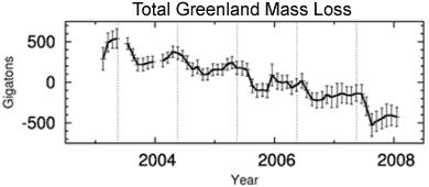
I've just updated the Greenland is losing ice page as a new paper analysing satellite data on Greenland mass change has been released (Wouters 2008). The Gravity Recovery and Climate Experiment (GRACE) measures changes in the Earth's gravity field and found that from February 2003 to January 2008, Greenland lost mass at a rate of 179 Gigatonnes per year. This is equivalent to a global sea level rise of 0.5mm per year. The rate is also increasing over time, suggesting an acceleration of mass loss.

Figure 1. Time series of the monthly GRACE data between February 2003 and January 2008, for the entire Greenland ice sheet.
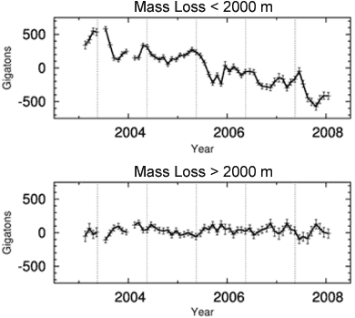
Figure 1 shows that mass builds up slowly between October and April, followed by rapid loss of mass between May and September. The vertical dashes indicate the middle of May, roughly coinciding with the start of the summer seasons. The paper also compares mass changes in regions below 2000m (eg - coastal regions) with the Greenland interior (above 2000m).

Figure 2. Time series of the monthly GRACE data for regions below 2000 m (top) and regions above 2000 m (bottom).
The interior of Greenland (>2000 m) shows a statistically insignificant positive trend of 7 ± 18 Gt/yr and appears to be in mass balance. It's worth noting that periods of mass loss above 2000 m are generally accompanied by accumulation below 2000 m.
So what we see is the Greenland interior is in mass balance but losing mass around the coastal regions. This equates to an overall mass loss. On average, Greenland contributed 0.5 ± 0.1 mm/yr to global mean sea level rise between 2003 and 2008. Trends are increasingly negative, partly due to the record mass loss during the summer of 2007, when mass loss occurred also at high elevations.


 Arguments


 0
0  0
0


Comments