Fasullo (2013) Seeks Some Levelheadedness Regarding Sea Level Variability
Posted on 23 August 2013 by John Fasullo
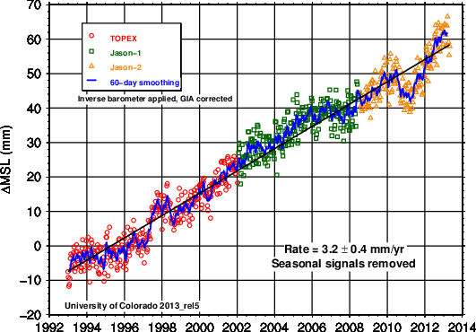
In 2011 an anomalous drop in sea level occurred that was so strong that the altimeter-era trend of about +3.2 mm/yr was temporarily reversed (Fig. 1). The drop was the largest to occur in the altimeter era and accompanied one of the strongest La Niña events since 1950.
Figure 1: Global mean sea level timeseries from the University of Colorado (seasonal signal removed, Gia correction and inverse barometer applied).
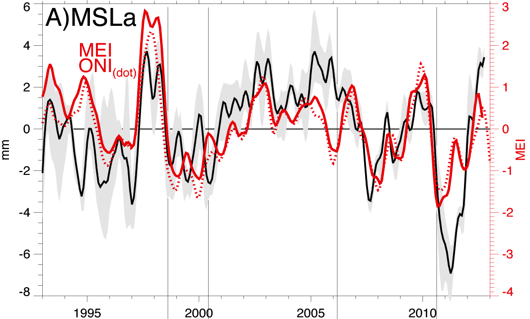
The drop was a unique opportunity to address a range of compelling science questions. Throughout the altimeter era, it has been recognized that sea level rise is not constant but varies considerably about the background trend, with the largest of these departures coinciding with the warm and cold phases of the El Niño Southern Oscillation (ENSO) such as in 1997–1998 (Fig. 2). However, lacking global observations of surface mass and ocean heat content capable of resolving year to year variations with sufficient accuracy, comprehensive diagnosis of the events early in the altimetry record (e.g. such as determining the relative roles of thermal expansion versus mass changes) has remained elusive.
Figure 2: De-trended global mean sea level based on estimates provided of the 5 major altimetry groups with their mean (black-solid) and full range (grey shading). Metrics of ENSO based on the Multivariate ENSO Index (MEI) and Objective Niño Index (ONI) are shown in red.
With GRACE retrievals of surface mass commencing in 2002 and ARGO-derived estimates of global ocean heat content beginning a few years later, an era of unprecedented diagnostic capabilities began. Boening et al. [2012] examined these data and found them to provide a consistent explanation of the drop as a consequence of the anomalous terrestrial storage of water at low latitudes that was linked to the accompanying La Niña. Contributions to the event arising from changes in ocean heat content were shown to be negligible. While answering basic questions regarding "what" happened during the event, the study also motivated several questions regarding "why" and "how" it happened including:
- If the 2011 sea level drop was driven by La Niña, why have drops of similar magnitude not accompanied other La Niña events in the altimeter era?
- How can rainfall anomalies over land be responsible for such a prolonged drop when the runoff timescale for most land regions is a few months or so?
- Lastly, how frequently do drops similar to the one in 2011 occur and does evidence exist in the historical record for other such drops?
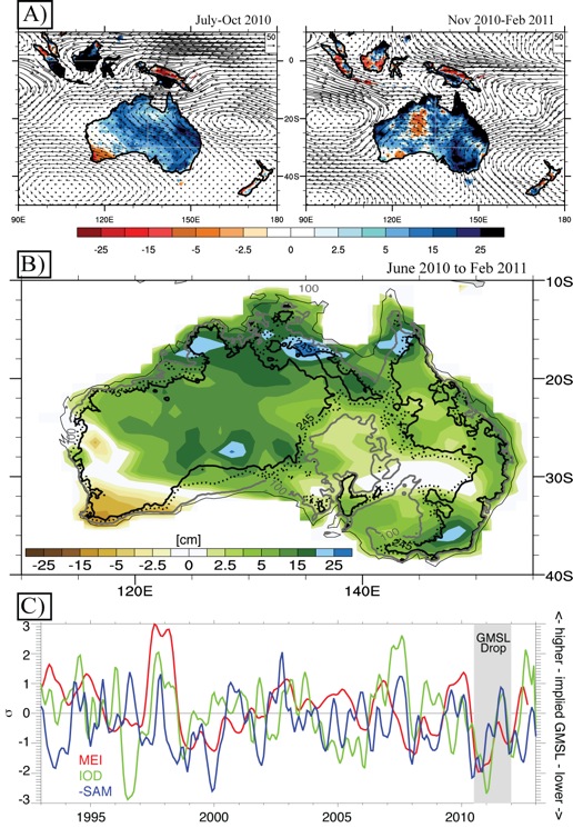
Figure 3: A) Anomalies in TRMM rainfall (colors, 0.1 mm day-1) and ERA-I water vapor transport (vectors, kg m-1 s-1) during the months of peak SAM (left) and MEI/IOD (right). B) The change in mass in Australia as reported by GRACE-CSR from June 2010 to Feb 2011. Contours represent land surface elevation isopleths (0 m, 100 m, 190 m, and 245 m) in order to emphasize the Western Plateau (west) and saddle point in northeast Australia, south of which rivers flow into the continent's interior. C) Evolution of major modes influencing Australian rainfall.
Using surface, satellite, and reanalysis data, Fasullo et al [2013] explore these questions and show that anomalous terrestrial storage in Australia was a dominant contributor to the global total in 2011. Moreover, a key factor distinguishing the 2011 La Niña from other recent events was the intensity and duration of flooding in Australia's interior, a region characterized by extensive interior drainage basins in which rainfall is either stored locally at the surface before evaporating or carried by rivers towards lakes in the center of the continent rather than discharging into the ocean. These interior basins are key to the fact that the continent's runoff ratio is just 6% in the climatological mean (as compared to 30%-40% for other continents).
Using reanalysis moisture budgets and drawing on the attribution work of others (e.g. Hendon et al. [2013]), Fasullo et al. [2013] demonstrate that the 2011 La Niña was also distinct from others in the altimeter era in that it coincided with a strong negative phase of the Indian Ocean Dipole (IOD) and positive phase of the Southern Annular Mode (SAM) (Fig. 3c). Together these influences drove exceptional moisture transports into the continent's interior (Fig. 3a) and were likely responsible for one of the wettest intervals in Australia's recorded history, the intensity and persistence of its terrestrial storage anomaly, and a considerable fraction of the global sea level response.
Extending the analysis to Australia's surface rain gauge record over the past century suggests that only in 1973–1974 has an event of similar magnitude occurred and thus similar events seem to be exceedingly rare. Moreover, there exists the potential for both internal decadal variability and climate change to modulate the severity of such events, through modulation of SST in the Western Pacific Ocean and related atmospheric moisture transports into Australia's interior. Understanding these low frequency influences remains a work in progress.
Misinterpretation of the 2011 Sea Level Drop
A common misunderstanding amongst climate change "skeptics" is the difference between short-term variability, such as events like this, and the long-term climate change signal. While much attention has been paid to the fact that evaluating warming trends over short intervals is problematic, less attention has been given to the obstacles involved in evaluating sea level rise with relatively short records, for example such as that provided from radar altimetry. Detecting an acceleration in either of these fields is an even greater challenge due to the potential for internal climate variability to obscure any longer term changes.
Yet the 2011 drop served as the basis for a number of misleading and ill-informed commentaries. Like the brief El Niño-induced pulse in global temperature in 1998, the 2011 sea level drop became a convenient "skeptic" endpoint over which to evaluate trends, accompanied by inappropriate claims that the drop debunked the acceleration of sea level rise over the past century seen in the combined gauge and altimetry records (and here), and revealed fundamental flaws in climate model projections (and here). Exploiting the 2011 endpoint, claims were also made that the data confirmed global warming's cessation or somehow reflected insights provided by new satellites (also here) Some posts even maintained that the acceleration in sea level was negative, and that a web site redesign by the sea level group at the University of Colorado was suspicious or even part of a conspiracy to withhold data.
A primary finding of both Boening et al. [2012] and Fasullo et al. [2013] is that the processes driving these interannual variations in sea level are physically distinct from those driving the background trend, as neither oceanic warming nor cryospheric melting played prominent roles in the event. Using the 2011 drop therefore as an indicator of changes in the background trend is therefore unwarranted. Recognizing these facts, and now that sea level has recovered and even risen well above the altimeter era background trend (Fig. 1), one is left to wonder, "Where are the errata for these demonstrably erroneous posts?"
Broader Implications and Challenges
The 2011 drop provides a unique opportunity to both appreciate the beautifully complex and interactive nature of the climate system, and highlight the need to have a comprehensive observing system in place to understand it. The drop also presents an important opportunity to challenge climate models, as many models simulate excessive rainfall in Australia's interior and their land surface schemes are therefore left to deal with unrealistically large associated fluxes of moisture. To account for these biases, many land models impose artificial surface closure schemes but these are physically unrealistic and undermine direct comparison to GRACE data. The event therefore also highlights the a need to improve our models to both be able to simulate events such as the 2011 drop and to be physically realistic so as to promote evaluation with available observations.
The observing system is at risk
As climate continues to change, there is the expectation that sea level will be a vital indicator of its severity and effects, but separating the background signal from natural variability on interannual and decadal timescales (e.g. Hu and Deser [2013]) will depend critically on insights provided by a capable observing system. With the decommissioning of the Jason-1 satellite in July of this year, only the Jason-2 altimeter remains to monitor global sea level. Launched in 2008, the satellite is already well past its original 3-year design lifetime and the follow-on Jason-3 is not planned for launch until 2015.
The surface mass record is similarly at risk. GRACE's twin satellite constellation has already lived well past its original 5-yr mission duration and battery problems now require the satellites to be shut down for about two months per year, resulting in gaps in its record that are expected to grow over time as its batteries continue to degrade. The GRACE follow-on mission is not planned to launch until 2017. Lacking these crucial data, both our understanding of climate variability and change, and our informed stewardship of this wondrous planet, can only suffer.
References
Boening, C., Willis, J. K., Landerer, F. W., Nerem, R. S., & Fasullo, J. (2012). The 2011 La Niña: So strong, the oceans fell. Geophysical Research Letters, 39(19).
Fasullo, J.T., C. Boening, Landerer, F. W., Nerem, R. S., (2013). Australia's unique influence on global sea level in 2010–2011. Geo. Res. Lett., DOI: 10.1002/grl.50834.
Hendon, Harry H., et al. "Causes and predictability of the record wet east Australian spring 2010." Climate Dynamics (2013): 1-20.
Hu, A., & Deser, C. (2013). Uncertainty in future regional sea level rise due to internal climate variability. Geophysical Research Letters.


 Arguments


A highly informative post. Thanks.
Ah yes, 2011. The year sea level drop was supposed to be the "final nail in the coffin" for global warming.
So many blogs claiming that the sea level dipping back to 2007-ish levels was somehow a lasting reversal of a decades long trend. Excoriating the climate models. Ridiculing NASA for—accurately, as it turns out—calling it a "pothole". Even halfway out of the "pothole" in 2012, some were still cherry picking those last few months to claim "no upward trend".
John
great post thanks. Good to see the science going forward. Many thanks again. I am becoming more optimistic that good science rather than disinformation is winning the day. A year ago I was deeply depressed that we were entering a new dark age.
StB
Thanks for the article, John.
The text answers the two of your bullet points:
- why have drops of similar magnitude not accompanied other La Niña events in the altimeter era? (coincidence of MEI and IOD & SAM is required as seen on figure 3c)
- how can rainfall anomalies over land be responsible for such a prolonged drop? (because of unique shape of the AU continent whereax the runoff goes into lake Eyre)
But the answer to the third bullet point:
- how frequently do drops similar to the one in 2011 occur? does evidence exist in the historical record for other such drops?
does not apear obvious to me, because I don't have access to the full text. I've downloaded figure S4 and I can see the rainfall map from the 1973-74 event (setting the famous record flood levels in Brisbane for those who remember) showing the anomaly in the central basin as wide spread as the latest one. Obviously, that was before GRACE era, but I suspect the event should have left a discernible dip in the gauge record. Such dip (of 6-7mm) would have been the evidence answering that bullet point. Did you find it or was it to small to find?
Second question, what do you mean by "dominant contributor" in terms of the actual numbers? Did you establish an approx percentage of the contribution based of GRACE mass numbers?
Thanks again for a great piece of reaserch.
Hi Chris,
Thanks for the feedback. Yes, the answer regarding other such drops in the historical record is complicated by the fact that our observations prior to GRACE and ARGO are incomplete, and prior to altimetry, are exceptionally so. We know that no comparable events occurred in the altimetry record. The gauge record of sea level is quite noisy on interannual time scales and so it is of limited use for identifying other events. There are comparable dips to that in 2010-11, but their credibility is highly questionable as they occur often and likely result from noise, not signal. And so what data to use?
If we were to argue that other events would require anomalous rainfall over Australia's interior basins comparable to that in 2010-11, then we could use the rainfall record to infer such sea level drops. In this case 1973-74 appears to be a comparable interval. Nonetheless, the assumption that the dips can only occur when Australian rainfall is high is questionable. Perhaps models will provide some perspective on this, and this is a possibility we are now exploring. Stay tuned!
In terms of 'dominant contributor', yes we did establish a % contribution. It varies somewhat depending on which GRACE product you use and at what time you evaluate the contribution. At the peak of the event, Australia made up about 50% of the storage +anomaly, with South America and North America, contributing about 30% and 20% respectively. But the anomalies in the Americas were relatively short lived whereas Australia's persisted for over a year. So at these longer time scales, Australia's influence was not only dominant, but solitary and unique.
Thanks for the informative/constructive feedback everyone! It is nice to read a blog where facts are the focus.
John
Great description, thanks.
~ ~ ~
If this topic interests you, check out:
Jerry Mitrovica, Harvard University on YouTube
SacklerColloquia
Finger Prints of Sea-level Rise
~ and ~
UCTV
Global Sea Level: An Enigma - Perspectives on Ocean Science
I'm sorry, I screwed that up "Global Sea Level: An Enigma" is by Dr. Walter Munk -
it's a so-so lecture, OK - but it's the following lecture that's the real eye opener.
~ ~ ~ ~ ~ ~ ~
"In Search of Lost Time: Ancient Eclipses, Roman Fish Tanks and the Enigma of Global Sea Level Rise"
"Jerry X. Mitrovica, Ph.D., is a Professor of Geophysics in the Department of Earth and Planetary Sciences at Harvard University, a Fellow of the American Geophysical Union, and the Director of the Earth Systems Evolution Program of the Canadian Institute for Advanced Research. ..."
~ ~ ~
"... Mitrovica will describe the important role these archaeological treasures have played in the understanding of sea-level rise and how they help scientists both "fingerprint" sources of recent sea level changes and make more accurate projections of future sea levels. ..."